|
| | | |
| |
|
| Backpack | 13.00 Miles |
2,010 AEG |
| | Backpack | 13.00 Miles | 24 Hrs | | 0.54 mph |
| 2,010 ft AEG | | | | |
|
|
| |
| Linked |
|
none
[ show ]
| no linked trail guides |
| Partners |
|
none
[ show ]
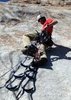
| no partners | | Really needed to get out on a backpacking trip, and really wanted to take my dog on his first overnighter. So after looking for a trail close to the valley, with water, and with a good distance, Reavis Falls fit right in.
Also had to use some new gear, since it doesn't do any good sitting in the closet. Made it on this trip with a 20lb total pack weight, including water. Tucker (my dog) had to carry his own food 
Got a 9am start at the TH. Passed a couple people heading out, we seemed to be the only ones going in. Tucker kept a swift pace, GPS saying we did a little over 3 mph up till the Falls turnoff. The trek down did seem to take forever though, it just keeps going down, and down. The idea of comming back up already in your mind also. We got to that first nice camp spot 3 hours after starting our trek, seemed as good as any, so setup camp there. Once settled, we headed off to the falls. Lots of carins along the way! Falls were being blown by the wind, and turned all the falling water into really cold mist. Took a few pictures, and headed back.
Went to sleep super early. Only good place to be was in the tent anyways. Lots of bugs out! Woke up rested at around 4:20am, had some breakfast, packed up and hit the trail out by 5:00am still in the dark. Used the headlamp for about 30 min, and caught the sunrise almost at the saddle (by the old tree). Made it back to the car in a little over 3 hours and headed home.
Good trip, can't wait till the next. |
| _____________________
| | |
|
|
|
 Route Editor