|
| | | |
| |
|
| Hiking | 9.01 Miles |
4,884 AEG |
| | Hiking | 9.01 Miles | | | |
| 4,884 ft AEG | | 55 LBS Pack | | |
|
|
| |
| Linked |
|
none
[ show ]
| no linked trail guides |
| Partners |
|
none
[ show ]
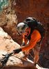
| no partners | | | Started at 8am. About 10mins in from Pima Canyon TH, went up the ridge leading to Pusch Peak. Reached Pusch Peak at 10:30am. From Pusch Peak down to the saddle beneath the Cleaver. Bypassed the Cleaver on the west side then straight up the steep slope to Bighorn Mountain. Reached Bighorn at 2:25pm. Continued from Bighorn to the top of Table Mountain. Reached Table at 4pm. Constructed a nice shelter in front of the fireplace and got a nice fire going. It was a very cold night, probably down into the teens, but at least it didn't rain or snow. In the morning (of the 23rd) we rappelled down the obvious NW facing gully that is maybe 100yds south of the campsite. Started just after 10am. That route has a lot of down climbing and requires two rappels, one ~80ft the other ~105ft. Lots of thick ice all the way down this gully, made things a little interesting. Three bolt anchors at the top of each rappel, but some of the bolts are old and hardly inspire confidence. From there hiked out the climber's aproach trail leading to the picnic area in the Ram's Canyon neighborhood off Oracle Road. Nice hike, and a lot of work to hit all three major peaks of Pusch Ridge in a day, and then our added adventure of coming down the north side. Hit the pavement at 3:55pm. |
| _____________________
| | |
|
|
|
 Route Editor