|
| | | |
| |
|
| Hiking | 8.00 Miles |
2,718 AEG |
| | Hiking | 8.00 Miles | | | |
| 2,718 ft AEG | | | | |
|
|
| |
| Linked |
|
none
[ show ]
| no linked trail guides |
| Partners |
|
none
[ show ]
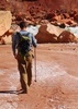
| no partners | | i parked at a sleading area about 1 mile past the nortic center. it was ~5 miles as a bird flies to the top. the snow was somewhat melted, which made travel hard because the snow was sticking to the showshoes. the weather was nice on the way there, clear until... a giant dark cloud cover me.
near the top the trail got steep, i had found the trail, but it didn't do me any good to stay on it, so i just went straight up. taking a step in snowshoes with wet snow is like one step up and a half of step slide back and repeat, my arms and legs were tired.
so because i was laly galin around i didn't start this hike till 3pm, and made it to the cabin at 7 40pm. this put me in the dark for the last hour because of the clouds. but i knew the the cabin would be nice so i continued. without a headlamp i might add, i thought i forgot it, but later i found it in a different part of my pack.
the night was great, the cabin blocked all the wind and i was eye level with the window so i could watch the wind and snow gather around the cabin. this was very nice, if you think you could get up there in the winter, do it.
on the way down i forgot to mark the car on the GPS, so i ended up hitting 180 about 5 miles north of my car, so there i am walking down 180 in a white out with car after car not giving me a ride. if your a hiker and see a hiker walking on the road, GIVE THEM A RIDE, its good carma. finally i ran into some CC skiers and they gave me a ride to my car, which you can see be the pic. that was burried in snow. i packed the trail with the snowshoes than gave it a try, after some back and forth i made it out, when i did i stopped and yelled back at this guy watching me and said, "can you believe that?" he said not if i didn't see it. great trip and next week yosemite.. |
| _____________________
| | |
|
|
|
 Route Editor