|
| | | |
| |
| |
| |
| Linked |
|
none
[ show ]
| no linked trail guides |
| Partners |
|
none
[ show ]
| no partners | | Rambling, random thoughts:
A close approach, but not necessarily a gimmie summit.
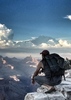
-Loose scree with consequences, fryable rock higher up, and some good ol' Canyon exposure traverses. I LOVE it!-
We decided to park about .4 miles before (west) Buggeln Picnic area in order to stay out of the drainage. Heading too directly to the rim, we traversed the edge to the east and could see the ridge that we needed to hit pretty quickly. There was snow on the ground so we just kinda picked the best meandering path down until hitting the blocky boulders that line the ridge. Some fun up, over, around, through, led very quickly to the base of the South summit where we explored the east side a bit before the scramble up. We just kinda let ourselves be led up the most obvious path with very few turn backs and found a couple of the scrambles to be exposed but no big deals. We found ourselves more on the East side of the blocks but found a break (after a really cool window!) and were able to traverse over to the West side where the key chimney is found. Then the loose scree to the giant chockstone was in front of us. The way up actually felt fine and with a few good high reaches and pulls, we were up that part that I thought was to be the crux. Shortly after that, we were on the summi...oh wait, this is actually a Falsie!! Time to drop down a bit and head over to the actual summit. A scramble to the left, under a super pointy boulder, found us at a choice of either an exposed stem gem move lookers left, or some 4th class bulge wrestling with a HUGE loose broken boulder on lookers right. I was very tempted to knock that bad boy off, but it was really the easiest way to get up...so... tread lightly on that temporary step up! After that, it was a fast last push to the summit and the Altoids register. The way down proved to be a bit harder on each section than the way up.  Watch that scree slope spot! Great little adventure, really nice views of other buttes and summits, and some fun limestone monkey time! Watch that scree slope spot! Great little adventure, really nice views of other buttes and summits, and some fun limestone monkey time! |
| _____________________
| | |
|
|
|
 Route Editor