|
| | | Hewitt Canyon Road to Reavis Ranch trail, AZ | | | |
|
|
Hewitt Canyon Road to Reavis Ranch trail, AZ
| | |
| |
|
| Hiking | 13.60 Miles |
2,350 AEG |
| | Hiking | 13.60 Miles | | | |
| 2,350 ft AEG | | | | |
|
|
| |
| Linked |
|
none
[ show ]
| no linked trail guides |
| Partners |
|
none
[ show ]
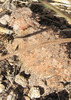
| no partners | | | Such a fun day we took the buggy out for a 16 mile drive on hewitt station road to hewitt canyon road. The dirt road was great fun in the buggy but very narrow and bumpy so wouldn't want to take a car over that. At the trail head we started a short out and back hike but saw tons of wildlife including a horned lizard, 2 tarantulas (black & az blond), hawk, mule deer, and cardinals. The plants were also lovely and some had started to change to fall colors making the hillside very pretty. The stony creek had a small amount of water and many plants had berries including a bush with red bark and red fruit. We didn't make it all the way to the apple trees so not sure if fruit there but a friend hiked this a couple of weeks back and said only a few were left. So a nice day and very pretty trail well worth the dirt road drive. |
| _____________________
| | |
|
|
|
 Route Editor