username
X
password
register
for free!
help
ArticlesGuidesRoutes
 
Photosets
 
 Comments
triplogs   photosets   labels comments more
5 triplogs
login for filter options
Nov 03 2013
avatar

 Photos 93
 Triplogs 5

64 male
 Joined Sep 11 2013
 Whetstone, AZ
Coin Slot in Kartchner Caverns State Park, AZ 
Coin Slot in Kartchner Caverns State Park, AZ
 
Hiking avatar Nov 03 2013
HeightmasterTriplogs 5
Hiking8.40 Miles 600 AEG
Hiking8.40 Miles   7 Hrs   20 Mns   1.15 mph
600 ft AEG45 LBS Pack
 no routes
1st trip
Linked   none no linked trail guides
Partners none no partners
I call this the Coin Slot for obvious reasons...to me, it looks like a coin slot in the cliff face. I headed west off of Hwy 90 into Kartchner Caverns State Park, and stayed westerly on Sands Ranch Road to its end. This was a rather peculiar road, due to it many wash crossings and large rock surfaces, but was able to reach its end, due SW of what I call this Coin Slot. The hike started at around 5200 feet, through some fairly heavy ground clutter. My goal was reaching the pictured cliff with this unusual, and mysterious, relief in its face. Visible from much of the surrounding area, it always appeared as a cave, so my curiosity won out and I had to investigate. I packed for an overnighter, just to be safe, and camera equipment for the sake of recording my findings along the way.

I had discovered the dry canyon along the road, a mine shaft of the vertical nature and various vistas which are not visible from well-travelled areas. Once out of the truck and actually hiking, the only real encounters were with mesquite and the odd beavertail, among other brush and cacti.

My hike took me up to the face of the cliff, only to discover the ledge on which I presumed would get me to the "Coin slot" was far too narrow and steep for a lone expedition to be wise. This did, however get me close enough to discern it was not a cave, but a peculiar notch in the cliff, that appeared as though it had been mechanically dug. There were no boulders below, signifying it had simply eroded...and no piles from a machine working the rock face...but there it is, a nearly perfect half-round indentation that looked as though a coin of gigantic proportion would fit into it. My final elevation was 5800 feet, approximately 200 feet below the height of its floor.

If anyone reading this triplog has any information (factual) about this strange dug out, I, for one, would be highly interested in knowing its origin.
 Fauna
 Fauna [ checklist ]
[ checklist ]  Red-tailed Hawk
 Culture
 Culture [ checklist ]
[ checklist ]  Mine Shaft
 Named place
 Named place [ checklist ]
[ checklist ]  Apache Peak  Whetstone Mountains
_____________________
Keep Your Head Up On a Swivel.
 
Oct 25 2013
avatar

 Photos 93
 Triplogs 5

64 male
 Joined Sep 11 2013
 Whetstone, AZ
Carr PeakTucson, AZ
Tucson, AZ
Hiking avatar Oct 25 2013
HeightmasterTriplogs 5
Hiking5.95 Miles 2,513 AEG
Hiking5.95 Miles   6 Hrs   42 Mns   0.89 mph
2,513 ft AEG
 no routes
1st trip
Linked   none no linked trail guides
Partners none no partners
Heading up Carr Peak trail #107, from Ramsey CG, proved to be quite the obstacle course! The leg of the trail between the CG and the Pines was definitely the worse. The trail improved a bunch after clearing the Pines.
The fall colors were popping all about, and the Aspens had already dropped their foliage. The first encounter of critterdom was here, within the Manse Nita...a Black Tarantula. Amazingly, this would be the only non-bird encounter the whole way. Besides fellow hikers that is.
The air was crisp at 7 a.m., but the winds of the previous days had filled the area with dust. This was quite prevalent looking out towards surrounding mountains. They were visible, yet silhouetted and without detail. All along the horizon, the brilliant blues were skirted by a brownish-grey leaving little definition along the way.
As I ascended, it was obvious trail assessors had been there recently. The pink ribbons were along the trail nearly all the way up to the Aspen grove. Descriptions of trail conditions were written on them, as though to prove they were there.
Just beyond the Aspens, a cave, of sorts, was discovered on the trail's left side. The undergrowth and conditions made intense investigation unjustifiable, but observations of the rapid dissension and entrance into the mountain incurred the opinion that this was a type of exhaust for snow melt waters. Upon further travel up-trail, this theory was proved by a giant reservoir on the opposite side. There was no visible link to the exhaust, so I concluded the reservoir would seep through and slow the flow. Further investigation during the spring snow-melt will prove valuable in this matter.
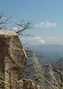
Venturing on, the eastern most switchback became a final resting place before encountering the last steep leg of the summit trail. It also became our highest point of this venture, due to time constraints. This switchback exposed the views over to the Mule Mountains, and into Mexico towards San Jose Peak. The rock bluff of the summit was just beyond, but the victims of the '11 Monument Fire were standing in memorial, parched and black, attesting to the spots where they were once great shadow-casters. A faint scent of ash still lingered when near one of these mighty reminders.
With over two hundred photos taken, and a bit over four hours hike time passed, the summit was reachable, but not on this hike! The return took half the time.
 Flora
 Flora [ checklist ]
[ checklist ]  Coral Bells
 Culture
 Culture [ checklist ]
[ checklist ]  Ghost?
foliage observationfoliage observationfoliage observationfoliage observationfoliage observation
Autumn Foliage Observation Moderate
The Aspens were bare, with the brilliant yellows and oranges of the walnuts, oaks and junipers sprinkled about the mountain sides.
_____________________
Keep Your Head Up On a Swivel.
 
Oct 01 2013
avatar

 Photos 93
 Triplogs 5

64 male
 Joined Sep 11 2013
 Whetstone, AZ
Raspberry Ridge Trail #228Tucson, AZ
Tucson, AZ
Hiking avatar Oct 01 2013
HeightmasterTriplogs 5
Hiking2.00 Miles
Hiking2.00 Miles   4 Hrs   15 Mns   0.47 mph
 no routes
1st trip
Linked   none no linked trail guides
Partners none no partners
We headed out, long before sun-up, to get the early morning shadows of Rucker Canyon. After the two hour drive, I was so ready to hike! Parking at the end of E Rucker Canyon Rd, in the last picnic area, we chose to go up, so Bear Canyon was the preferred direction. The hike started out on Raspberry trail #228, and about a half mile into it, my photo bud and I both thought: "Up"! Seeing all kinds of scat, we decided to seek the Raspberry Ridge that went up the west side of Bear Canyon. An excellent hike and even better photo ops!

The ridges ahead, and behind, us were starting to lighten up with brilliant colors and long shadows, and the air was crisp and clean. We went nearly to the top of Raspberry Peak when we noticed a dry creek bed, with rock formations denoting a terrific waterfall area, when the water is running.

After getting some great shots, we checked our water supply and time and determined returning would be acceptable. However, my idea of following the creek bed was cut short by a serious 20' drop in the rock levels. We cut back up into the ridge under-growth for a spell, then right back down into the creek bed. Never did catch a glimpse of a bear, or any other four-legged creature, bigger than a Western Fence Lizard.

We finally arrived at the river shortly after 11 a.m., and took a few more shots before disembarking our terrific hike.
foliage observationfoliage observationfoliage observationfoliage observationfoliage observation
Autumn Foliage Observation Light
We observed the following: English Daisies; Arizona Poppy and Beardtongue.
_____________________
Keep Your Head Up On a Swivel.
 
Sep 21 2013
avatar

 Photos 93
 Triplogs 5

64 male
 Joined Sep 11 2013
 Whetstone, AZ
Ramsey Canyon TrailTucson, AZ
Tucson, AZ
Hiking avatar Sep 21 2013
HeightmasterTriplogs 5
Hiking2.10 Miles 700 AEG
Hiking2.10 Miles   7 Hrs   21 Mns   0.29 mph
700 ft AEG
 no routes
1st trip
Linked   none no linked trail guides
Partners none no partners
This photo-hike began at 8 am, as the sun was clearing the ridges to the entrance of Ramsey Canyon. The skies were clear with lightly spotted clouds, which built as the day progressed.
The interesting sights began as soon as we passed through the visitor's center to the trail head at Ramsey Creek. Our objective was to reach the Overlook and return.

The first real photo opportunity was at the Bedrock Waterfall. This granite outcropping of igneous rock was said to have been formed by slow cooling molten material from deep within the earth's surface about 1.4 billion years ago. The natural dam these rocks create offered sanctuary for birds, arroyo willows, sedges, scouring rush (of the horse tail family)and locust trees. The noticeable falls are seemingly shooting water straight up.

The next stop, of any time length, was the James House Overlook. An old house built in 1911, which the James family lived in after growing out of the later mentioned cabin. It's location was well-thought in relation to the sun and the creek. It's back is against the rising northern face of the canyon, while it façade looked out over the creek as the sun lit up the canyon floor and the area where nearly 100 settlers lived between 1880 and 1930.

Shortly after the Overlook House we discovered the cabin. The James Cabin was built in 1902 but is now inhabited by various creatures who find its voids and crevices irresistible.

From there, the many Sycamores, Mexican Locusts, Agave and assorted other plants and flowers caught our attention as we began the steeper rise to the Hamburg trail and the Overlook. Once past the Grizzly-scratched utility pole and rock wall that marks the Bledsoe loop, our hike became a bit more intense. The benches provided for resting seemed well-placed, as the grade took its tool on the calves and lungs. The frequency of our photo opportunities kept us from overdoing the ascension, so we basked in the silence of the wind and water which filled the area with constant rustling. We only experienced a couple fellow hikers on the way up.

Once we reached the Overlook, the Ramsey Peak was the center of attention. Some of the outcroppings of rock proved that the material was once liquid and cooled to solidity. Quite amazing veining! Water and almonds were enjoyed for a time, then our decision was to continue on down to the stream for more photo opps. This was a very rocky descent and inattentiveness would sprang an ankle quite easily.

We got as far as Comfort Springs trail's beginning, and decided to make the return trip. Our water was at half, and the photos were quite numerous by then. The return back to the visitor's center would introduce us to quite a few folks, and a whole gaggle of children enjoying the day.

If you've never experienced the Nature Conservancy's Ramsey Canyon Preserve, it will surely thrill your senses.
 Named place
 Named place [ checklist ]
[ checklist ]  Miller Peak Wilderness
 Meteorology
 Meteorology [ checklist ]
[ checklist ]  Moon
_____________________
Keep Your Head Up On a Swivel.
 
Sep 13 2013
avatar

 Photos 93
 Triplogs 5

64 male
 Joined Sep 11 2013
 Whetstone, AZ
Clark Spring Trail #40Prescott, AZ
Prescott, AZ
Hiking avatar Sep 13 2013
HeightmasterTriplogs 5
Hiking1.75 Miles 747 AEG
Hiking1.75 Miles   4 Hrs   20 Mns   0.40 mph
747 ft AEG
 no routesno photosets
1st trip
Linked   none no linked trail guides
Partners none no partners
Being new to the area, but having hiked the Ozark Mountains back in the Midwest, a casual photo trip into the Carr Canyon turned into a modest hike up Clark Spring Trail #124. The trail could have been traversed most of the way by vehicle, but started out very rutted and the idea was to take nature shots...not easily done from a vehicle.

We parked on the first serious switchback of Carr Canyon road, just a click or so past the falls. There is where I found the trail head. A rather easy hike, but these elevations wore fast on me, and our hike was limited by available water.

Hiking is one thing...picture taking makes it a whole different experience! Very casual, often motionless, waiting for the right light on a subject, this was more of a photographic excursion than a hike.

The scenery, which is all new to me, was pleasantly breath-taking! The remaining evidence of a past fire provided some interesting contrast to the vistas. The morning clouds were at a low ceiling, capping the southern rim of Carr Canyon, and the breaking scattered shadows along the valley floor resembling fire-ravaged areas. All too awesome!
wildflower observationwildflower observationwildflower observationwildflower observationwildflower observation
Wildflowers Observation Light
There were a half-dozen species along the trail, from tiny orchid-style flowers to one huge single bloom of what was reported as poisonous. My knowledge of names is growing, be patient.
_____________________
Keep Your Head Up On a Swivel.
 
average hiking speed 1.02 mph

WARNING! Hiking and outdoor related sports can be dangerous. Be responsible and prepare for the trip. Study the area you are entering and plan accordingly. Dress for the current and unexpected weather changes. Take plenty of water. Never go alone. Make an itinerary with your plan(s), route(s), destination(s) and expected return time. Give your itinerary to trusted family and/or friends.

helpcommentissue

end of page marker