Route Editor

| Guide | ♦ | 39 Triplogs | 0 Topics |
details | drive | permit | forecast | map |
stats |
photos | triplogs | topics | location |
| 518 | 39 | 0 |
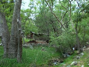
Through the portal we go! by PhilipMueller   In 1965, the site of the Ramsey Canyon Preserve was designated as the first Natural Landmark under the Historic Sites Act--a designation that honors outstanding ecological and geologic features on private land. On an August morning, my wife, Cindy, my son, Max, and I would quickly discover why this was the perfect place to be so honored. In 1965, the site of the Ramsey Canyon Preserve was designated as the first Natural Landmark under the Historic Sites Act--a designation that honors outstanding ecological and geologic features on private land. On an August morning, my wife, Cindy, my son, Max, and I would quickly discover why this was the perfect place to be so honored.The 380-acre preserve is owned and operated by The Nature Conservancy (TNC). Upon our arrival at the visitor's center, a knowledgeable volunteer named Bob briefed us on the unique geography that helps to make the preserve so special. Bob shared with us that the preserve lies within the intersection of the Sonoran and Chihuahuan deserts and the Rocky Mountains and the Sierra Madre of Mexico. Add the sky island of the Huachucas and water into the mix, and you have some pretty unique species of plants and animals wrapped in some fantastic geology. The visitor's center had a few small exhibits to view and lots of on-topic books for sale. The best part about the visitor's center, though, was that when we stepped out the back door like Lucy stepping through the wardrobe into Narnia, we realized that the visitor's center was a portal to a hidden and magical place.
After a total of about 1/10th of a mile on GVL, we were back on the main trail. We enjoyed the shade of trees such as Maples and giant Sycamores. We stopped to gaze in awe at one particular Sycamore... the largest I have ever seen... and read that it dated back to 1760! We have grown up together, our country, and you, old friend. Between the shade, the breeze cutting through the canyon, and the elevation of 5550 feet, the cool air made us forget that not far beyond the portal through which we had only a few minutes ago passed, was a strikingly different and hot southern Arizona summer. Within about 1/10th of a mile from GVL, we turned right onto the Bledsoe Loop (BL), named after the Dr. Nelson Bledsoe family. The Bledsoe's began purchasing Ramsey Canyon land in 1922 and ultimately acquired 280 acres, all of which the family donated to TNC in 1974. Thank you. "Look Max, Frogs!" I exclaimed. We were standing at the edge of the pond and reintroduction project for Chiricahua leopard frogs. Vibrantly green, they were--about the size of my fist. We read that they sing underwater. After a total of about 2/10ths of a mile on BL, we were back on the main trail. We had the option from here of heading up a series of switchbacks about 500 vertical feet in just 1/2 a mile to a lookout point, and we took it. The main trail we had been on was once part of a toll road that was built by the Canyon's namesake, Gardner Ramsey, who arrived in 1879. The road ran about 2.5 miles up to the Hamburg Mine area, named after Henry Hamburg, an early canyon resident. Prospectors mined for silver, gold, lead, copper, and zinc, although, TNC reports that the mining largely failed by 1931. We were now on the steep Hamburg Trail headed toward that lookout. The forest thinned a bit as we moved away from the creek, letting in a little more sun and heat. Max's 26 lbs or so on my back seemed to increase with each switchback. I was glad this was only going to be about 1/2 of a mile. We saw two signs that indicated we were leaving the preserve and entering the Coronado National Forest. We came upon an elderly man, who had also intended to get to the lookout. He told us he was going to quit. "It's just around the bend, I bet," he said. "It's always like that", he grumbled, as he turned around in defeat. He was right, It was just around the bend, less than 2/10ths of a mile from leaving the preserve. Thank you, teacher. The view from the lookout into the San Pedro River valley with thick monsoon clouds overhead in one direction and into the heavily wooded glory of upper Ramsey Canyon in the other was fantastic. "Look, a dragonfly", Cindy said. It was yellow and black with blue eyes and about 4 inches long... an absolute beauty. After we got back down to the main trail of the preserve, we came upon an area called Butterfly Seep. Here, water seeps from a hillside spring through the soil onto a short stretch of uncovered trail where male butterflies take in sun, moisture, and salt, which aid in reproduction. We saw about a dozen Arizona Sister butterflies here. Cindy aptly commented that it looked like a line of airplanes waiting to take off at a busy airport. After a total of about 2.10 miles, roundtrip, we passed back through the portal and into the parking lot. As I drove home, and Cindy and Max slept, I couldn't help but smile as I thought about what Cindy had said at one point during our little hike into Ramsey Canyon: "This is such a blessing, to be in this beautiful place with my family." Amen. Check out the Triplogs. Leave No Trace and +Add a Triplog after your hike to support this local community. | |||||||||||||||||||||||||||||||||||||||||||||||||||||||||||||||||||||||||||||||||||||||||||||||||||||||||||||||||||||||||||||||||||||||||||||||||||||||||||||||||||||||||||||