|
| | | |
| |
|
| Backpack | 15.60 Miles |
3,945 AEG |
| | Backpack | 15.60 Miles | 10 Hrs 43 Mns | | 1.64 mph |
| 3,945 ft AEG | | 5 LBS Pack | | |
|
|
| |
| Linked |
|
none
[ show ]
| no linked trail guides |
| Partners |
|
none
[ show ]
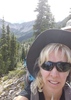
| no partners | | #41 of 50 hikes. Day 2 of 3. KING'S PEAK in the High Uintas Wilderness east of Salt Lake City Utah, here I come!!  My ultimate goal this year had finally arrived! I was super excited and extremely nervous. I knew this hike would be hard and had done my best to be prepared both physically and mentally. My ultimate goal this year had finally arrived! I was super excited and extremely nervous. I knew this hike would be hard and had done my best to be prepared both physically and mentally.  Started about 8am, should have started sooner, but we weren't in a hurry because no afternoon thunderstorms were in the forecast. Took it easy at the beginning to conserve energy for the grueling climbs to come. Our group got separated because of the varying hiking speeds. Not good. Jon was essentially my guide, lifeline, and supporter because this was his fifth time to King's Peak and I was relying on him. This was Coumarane's first time also, but kept up with Rich and Chris who were hiking faster. At some point along the trail, Jon and I veered off towards the "short cut" or "chute" or "Anderson Pass". We didn't follow a said-trail but followed a sheep trail to the pass. Eventually we caught up with Chris and Rich who were waiting for us at the bottom. No Coumarane. Found out Rich had gone ahead and also veered off the trail not knowing Coumarane was trying to catch up to him. Coumarane stayed on the trail, going up and over Gunsight Pass, thinking it was Anderson Pass, to only double back to the top of Gunsight Pass. Discovering his mistake, he continued back down Gunsight Pass and around and met us at the top of Anderson Pass. During this whole time (~2 hours), I am trying to climb, crawl, scramble, boulder, and pull myself up this formidable rock slide of a so-called short cut. Ugh. Started about 8am, should have started sooner, but we weren't in a hurry because no afternoon thunderstorms were in the forecast. Took it easy at the beginning to conserve energy for the grueling climbs to come. Our group got separated because of the varying hiking speeds. Not good. Jon was essentially my guide, lifeline, and supporter because this was his fifth time to King's Peak and I was relying on him. This was Coumarane's first time also, but kept up with Rich and Chris who were hiking faster. At some point along the trail, Jon and I veered off towards the "short cut" or "chute" or "Anderson Pass". We didn't follow a said-trail but followed a sheep trail to the pass. Eventually we caught up with Chris and Rich who were waiting for us at the bottom. No Coumarane. Found out Rich had gone ahead and also veered off the trail not knowing Coumarane was trying to catch up to him. Coumarane stayed on the trail, going up and over Gunsight Pass, thinking it was Anderson Pass, to only double back to the top of Gunsight Pass. Discovering his mistake, he continued back down Gunsight Pass and around and met us at the top of Anderson Pass. During this whole time (~2 hours), I am trying to climb, crawl, scramble, boulder, and pull myself up this formidable rock slide of a so-called short cut. Ugh.  I will never do that again and will discourage others for the rest of my life. AND I HAVEN'T EVEN STARTED CLIMBING UP TO KING'S PEAK YET!! I will never do that again and will discourage others for the rest of my life. AND I HAVEN'T EVEN STARTED CLIMBING UP TO KING'S PEAK YET!!  But I'm not a quitter, so I started rock climbing with Jon and Coumarane. Chris and Rich headed back; they were leaving early for work. (side note: they ended up taking the wrong trail heading to Gunsight Pass adding several miles to their trek, so they ended up staying the night again) But I'm not a quitter, so I started rock climbing with Jon and Coumarane. Chris and Rich headed back; they were leaving early for work. (side note: they ended up taking the wrong trail heading to Gunsight Pass adding several miles to their trek, so they ended up staying the night again)
Have I mentioned how hard I anticipated this hike was going to be? I was wrong--it was beyond difficult!!  We headed over to the "saddle" which is the ridge line that overlooks into the neighboring basin to the west. It's labeled as Anderson Pass on the Route Scout map. I don't know the west basin's name, but the east basin's name was Painter Basin. Again, I began to boulder my way up to the peak. About halfway up we were taking a break and suddenly there was a loud rumbling. I immediately thought of a rock slide had broken loose below us. We headed over to the "saddle" which is the ridge line that overlooks into the neighboring basin to the west. It's labeled as Anderson Pass on the Route Scout map. I don't know the west basin's name, but the east basin's name was Painter Basin. Again, I began to boulder my way up to the peak. About halfway up we were taking a break and suddenly there was a loud rumbling. I immediately thought of a rock slide had broken loose below us.  I was petrified. Jon looked just as nervous until he pointed behind me. I turned around and it was a mini dust devil/tornado!! It had the been the wind!! I've never heard anything more scary in my life as I'm sitting on a delicate, unsteady, rocky ridge! I was petrified. Jon looked just as nervous until he pointed behind me. I turned around and it was a mini dust devil/tornado!! It had the been the wind!! I've never heard anything more scary in my life as I'm sitting on a delicate, unsteady, rocky ridge!  At that moment I would have paid anything for a helicopter! It took almost 2 hours to summit. And I'm very grateful I made it. I took my pictures, ate and drank, and said, "Let's go!" As breathtaking as the views were, my nerves were shot. As we made our way down (there is no set trail), it seemed just as treacherous to go back the way we came when you could see the trail straight down at the bottom. Coumarane started heading down as I was trying to find a "safer" sideways down. Once again, we lost him. Jon valiantly tried to keep an eye on both of us, but eventually felt obligated to stay with me. We eventually headed straight down trying to find him. Sure enough, we finally spotted him waiting for us on the trail. I've never loved solid ground more once we were off that rock-infested-sheer-wall-of-a-mountain! That took about 1.5 hours to come down! At that moment I would have paid anything for a helicopter! It took almost 2 hours to summit. And I'm very grateful I made it. I took my pictures, ate and drank, and said, "Let's go!" As breathtaking as the views were, my nerves were shot. As we made our way down (there is no set trail), it seemed just as treacherous to go back the way we came when you could see the trail straight down at the bottom. Coumarane started heading down as I was trying to find a "safer" sideways down. Once again, we lost him. Jon valiantly tried to keep an eye on both of us, but eventually felt obligated to stay with me. We eventually headed straight down trying to find him. Sure enough, we finally spotted him waiting for us on the trail. I've never loved solid ground more once we were off that rock-infested-sheer-wall-of-a-mountain! That took about 1.5 hours to come down!
Clouds had moved in as we were scaling down the peak and it provided some needed shade from the hot sun even though the temps were around 50 degrees. We continued around and over Gunsight Pass (since I vowed never to do the "short cut" again!  ). Gunsight Pass was a good climb, but at least it had a trail to walk on instead of bouldering! It was still treacherous because we saw a dead horse at the bottom of a small drop off before we made it over. Once we made it over, it was a race back to base camp. What an adventure! I feel very accomplished and proud to say I've been on top of Utah at its highest point of 13,528 feet and lived to tell the tale!! It's an exciting chapter in my history book, but probably one I won't be repeating. ). Gunsight Pass was a good climb, but at least it had a trail to walk on instead of bouldering! It was still treacherous because we saw a dead horse at the bottom of a small drop off before we made it over. Once we made it over, it was a race back to base camp. What an adventure! I feel very accomplished and proud to say I've been on top of Utah at its highest point of 13,528 feet and lived to tell the tale!! It's an exciting chapter in my history book, but probably one I won't be repeating.  |
| | |
|
|
|
 Route Editor