 Route Editor

| Guide | ♦ | 121 Triplogs | 6 Topics |
details | drive | permit | forecast | 🔥 route |
stats |
photos | triplogs | topics | location |
| 1.6k | 121 | 6 |
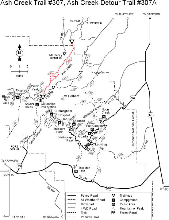
Difficult by madhiker   2017 Frye Fire 2017 Frye FireBest read the current triplogs. Pre Frye Fire Sometime during the sweltering heat of the Phoenix summer, when the asphalt becomes soft from the scorching sun and gives off a shimmering mirage as you walk down the street to your mailbox, you'll be wishing for a stroll in a lush cool forest with mountain streams flowing by fields of green grass and golden wildflowers. Come on; you know what I'm talking about! What you might not know is that such a place is only a few hours away. Yes, even in August! The forest is located on top of Mount Graham near Safford, and that "stroll" is along Ash Creek Trail #307. Ash Creek is one of the most beautiful forested hikes in Arizona. I would recommend a summer camping trip where you camp in the coolness of the mountains, 9000 ft above sea level. It's one of the fewest places in AZ where you still need a jacket in the middle of August, and it's not as crowded as Flagstaff. Get up early the next morning, hike the Ash Creek Trail from top to bottom, and then work your way back up. This is the route I'll describe here. Those bottom-up hikers can just read it in reverse.
This is a challenging but beautiful hike. Those who do not wish to brave the entire trek should consider turning around at Oak Flat (it'll be obvious when you get there) for about half the work. As you start, the trail descends the north side of Mount Graham through pleasant tall pines and fields of grasses dotted with wildflowers. The air is heavy with moisture, and lush flora lines the trail. Don't be surprised to see lots of wild mushrooms and leafy green plants. It would be almost like a tropical rainforest if it weren't 9,000 ft high. Ash Creek trickles by the side of the trail, and you'll have the distinct privilege of crossing it many times along the hike. Soon you'll come to the remains of an old boiler at a trail junction. Don't worry; the wooden posts and signs are quite good on the upper half of this trail and save for the occasional downed log to hop over, the trail is wide and easy to follow. There's a pack trail junction where horses go one way (along a longer path), and the more steady biped creatures go another. Along the main trail, you'll come to some scenic rocky areas reminiscent of Yosemite and have to walk along some platforms built into the rock. There's a small waterfall worth admiring as you descend through this area. The trail gets steep, and you'll encounter the bottom fork where the pack trail rejoins the main trail. Below that, the steepness continues and zigzags through some brush. You'll finally come to a wide grassy clearing with old campfire rings. Welcome to Oak Flat. Lots of shade here to take a rest. Those in their right minds should consider returning at this point. It takes 3 times as long to go back up as it does to come down, so save some gusto for the uphill. OK, the rest of you insane hikers like me should forge forward for some genuinely fantastic hiking. The trail gets a bit overgrown and difficult to find past Oak Flat. You can tell that the pack animals for which the trail was originally built haven't trampled these grounds in a good many years. The lack of human presence means the forest is even more pristine and beautiful. We saw plenty of fresh bear droppings, a whole family of coatimundi, and some cougars on the next hill over. The lower forest has more live oaks and maples than the pines higher up, but the lush vegetation makes it seem like you're hiking in the Appalachians instead of Arizona. Years of fallen leaves covered the ground and softened our steps. We had to look for the trail several times to make sure we're on the right track. After some switchbacks down a loose, steep slope, the trail eventually levels out a bit and suddenly opens up. It's like there's an instant "threshold" between deep forest and desert riparian terrain. You'll start to catch some views toward the desert floor to the north of Mount Graham. Hiking down through the dirt trail lined by cacti and agaves makes it more of an Arizona hiking experience. We stopped when the trail ended at a dirt road seemingly accessible via 4x4 from the town of Pima (Cliff Ranch Road, I think). Though there was no sign here, I gather this is the "forest boundary" mentioned on the plaque at the upper trailhead. (?) One drawback to hiking down first is that you have to work hard to go back up, but the nice thing is that the view improves as you go higher and the temperature gets cooler. It's a pure pleasure to cross the "threshold" into the shaded forest. The part from Oak Flat back up to the rocky waterfall area is KILLER, though! I'd estimate a mile and a half of steadily steep uphill. It sure gets the heart pumping! Your reward for the hard work is to end your hike among the fields of wildflowers and the pine-scented forest in the upper reaches of Ash Creek. This is one awesome butt-kicking hike, and I highly recommend it. NOTE 1: Watch out for poison ivy along the way. Come prepared with long pants. NOTE 2: According to the Safford Ranger Station, the recent fire (2004) spared this trail. It runs between the two burned-out regions on Mount Graham.
Coronado FS Details Ash Creek Trail #307 & Ash Creek Detour Trail #307A One of the Pinaleno range's larger streams has carved the route for this popular trail. As it drops from alpine forest to desert valley, Ash Creek Trail passes through all of the varied life zones that find a home on this unique mountain. Such a diverse set of surroundings makes this an excellent trail for encountering some of the varied wildlife species that inhabit the Pinalenos. Black bear, mountain lion, both mule, and white-tailed deer, javelina and coatimundi are just some of the animals you're likely to encounter if you proceed slowly and quietly and keep a watchful eye. If you like to fish for trout, you'll be interested to know that pools in the middle reaches of Ash Creek hold populations of native Apache trout. Ash Creek is not a large stream, so the fish are small, but they're wild and feisty nevertheless. If you come with that in mind, you'll enjoy the fact that they are quite a challenge to catch. Since this prominent drainage has long been used as a major travel route up the mountain, it has also accumulated several historic relics. Along the trail are remains of an old sawmill and a logging flume, as well as boilers for steam engines used by loggers. These rusty artifacts serve as evidence that this area was used for timber harvest before modern transportation methods made it cheaper to haul lumber from areas where it could be harvested more economically. Notes: This trail is suitable for horseback as well as foot travel; however, there is a stretch of the trail called slickrock that is particularly hazardous for horses. To avoid this section, take the 307A detour. Ash Creek has water in it year-round. Purification of water is recommended before use. Check out the Official Route and Triplogs. Note This is a more difficult hike. It would be unwise to attempt this without prior experience hiking. Leave No Trace and +Add a Triplog after your hike to support this local community. One-Way Notice This hike is listed as One-Way. When hiking several trails on a single "hike", log it with a generic name that describes the hike. Then link the trails traveled, check out the example. | |||||||||||||||||||||||||||||||||||||||||||||||||||||||||||||||||||||||||||||||||||||||||||||||||||||||||||||


