|
| | | |
| |
|
| Hiking | 5.78 Miles |
2,816 AEG |
| | Hiking | 5.78 Miles | 4 Hrs 54 Mns | | 1.37 mph |
| 2,816 ft AEG | 40 Mns Break | | | |
|
|
| |
| Linked |
|
none
[ show ]
| no linked trail guides |
| Partners |
|
none
[ show ]
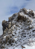
| no partners | | I parked at the start of FR 100; there was about 1.5 feet of snow in places along the road, and even if there wasn’t, a couple of fallen trees blocked the road starting about a quarter mile in. The trailhead is sparsely marked with a rock cairn; RouteScout was a huge help in finding it, in addition to keeping me on trail later.
Much of the trail on the north faces was still covered in snow, which made for slow going for the first mile or so. After that, the views opened up, but the trail didn’t: thick grass and brush covered much of the trail after Lane Spring, and made picking out the path nearly impossible without a combination of a GPS and RouteScout, particularly when the trail veered right off of a relatively well-established Jeep road (you can probably see my double back after I realized I missed the turn!).
From there, the trail rapidly descends into the valley, with brushy walls for the rest of the way. Fortunately, there was water flowing steadily just about everywhere the maps said there might be a seasonal creek, despite being on the side of the ridge where the snow had long since melted, which bode well for my overnight stay. I continued down to the end of the trail and turned right, taking the “Jeep road,” which is as overgrown as the rest of the path, 0.2 miles down near Copper Creek, which was flowing furiously with pools up to 2 feet deep in places. It was there I set up camp.
The hike out was a bit more miserable, but nothing unmanageable. The thick brush made trail-finding more difficult going uphill than it was downhill, but I had the benefit of a little prior experience with the route this time. I consulted RouteScout more often, and as such, didn’t manage to meander so far off the path.
All told, I’d call this a pretty decent backpacking trail for this time of the year. It’d be a bit intense to day hike the whole thing, but the plentiful water and clear views made it an enjoyable experience. At this time of year, though, some snowshoes and a machete would be worth the extra weight! |
| | |
|
|
|
 Route Editor