 Route Editor

| Guide | ♦ | 15 Triplogs | 1 Topic |
details | drive | permit | forecast | 🔥 route |
stats |
photos | triplogs | topic | location |
| 0 | 15 | 1 |
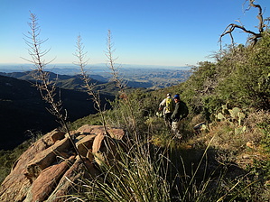
Advanced Trail Hiking by joebartels   Overview OverviewHeads down from 7,000 feet to Copper Canyon through historic mining country. Panoramic views include the southern Bradshaw Mountain Range, Copper Canyon, and Lake Pleasant 16 miles to the south. History The trail passes the Lane Mine, one of the first silver mines established in the Bradshaw Mountains. The ore from this mine was so rich that it was packed on burros to Wickenburg, put on wagons, and transported to Yuma, then sent by steamship to France where the ore was refined.
Upper access is said to be at the end of FR 100. It's really alongside it a mile in and the road continues. There is no signage or even a path denoting the origin of #233. As of this writing, there was some faded tape flagging. 20-50 yards in it starts to feel like a faint trail. It shouldn't take long to be on an apparent trail. Live oak chaparral is typically near and dear. Catclaw tugs in areas, nothing horrible, it seemed par for course. Wrapping around Lane Mountain proper you pass near Sullivan Spring on the east and Lion Spring on the south side. After which it heads down more in a serious fashion. As of 2013 an obtrusive 2 inch diameter ABS pipe follows the trail. The tread is loose in areas of steeper grade. Without a GPS route, you might lose the trail too. Perhaps of little interest to anyone, right? To date, I've hiked it twice. The Bradshaw range intrigues me and I enjoy the distant views. Views predominantly span from South Mountain to the White Tanks. Lane Mine is 2.55mi down #233 proper, just a tenth of a mile before Lane Spring. The topographical map depicts it a couple of paces to the west. Other sources proclaim it's a couple of paces to the east. Check it out. I'm more into women, fast cars, and rolling dice... I wasn't aware until now. Judging by the satellite view it's been cleaned up very well. The end is said to be where it meets FR 9286K. Unless you own an aftermarket 4WD doohickey... hike 2.5 mi down to 7-Eleven ( FR 711 ). I suspect the FS did not convert to FR 9286K from road to trail status as 0.65 mi is outside of the Prescott National Forest. In less remote areas they would likely cut a trail to an easier accessible road. Water Lion Spring appears reliable after two visits. We witnessed a very small pool in Aug 2012 and Sept 2013. Copper Creek Spring at the bottom looks more reliable or at least has large pools nearby. Check out the Official Route and Triplogs. Leave No Trace and +Add a Triplog after your hike to support this local community. One-Way Notice This hike is listed as One-Way. When hiking several trails on a single "hike", log it with a generic name that describes the hike. Then link the trails traveled, check out the example. | |||||||||||||||||||||||||||||||||||||||||||||||||||||||||||||||||||||||||||||||||||||||||||||||||||||||||||||||||||||||||||||||||||||||||||||||||||||||||||||||||||||||||||||||||||||||||||||||||||||


