 Route Editor

| Guide | ♦ | 93 Triplogs | 7 Topics |
details | drive | no permit | forecast | route |
stats |
photos | triplogs | topics | location |
| 554 | 93 | 7 |
Canyons are inherently risky. Flash floods occur without notice on sunny days. Technical skills & surrounding topography knowledge required yet does not eliminate risk.
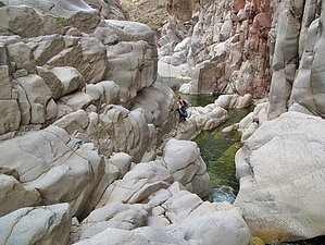
Swimmin' UP the Tonto by joebartels   Note NoteAs of January 2009 the access described below has been permanently closed. This GPS Route will get you in legal, if followed carefully. Here's the accompanying triplog. Warning More scrambling & swimming than actual hiking on this trip. Travel in the creek is much slower than hiking a maintained trail. Beware of flooding. Tonto Creek reaches water flows in excess of fifty thousand cubic feet per second.
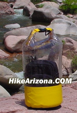
The approach, attraction, and possibilities make this escape a true classic. Getting to the trailhead might be an adventure in itself. None of the roads are marked. I spent about twenty minutes looking for the right area. The good news being Gisela is a very tiny town, and twenty minutes will cover the whole town. If you go into the town of Gisela, you're actually wasting time. Try the directions below. Please feel free to e-mail better directions, and I'll get them posted. From the trailhead (the gate), you will follow the dirt road to Houston Creek. It's about 0.6 miles along the dirt road. This may seem like a hassle going in. On the way out, it gives your clothes a chance to dry out before jumping back in the car. The road actually goes to a farm. A sign leads you down into the creek just before the home. I doubt the homeowners are too thrilled living next to this major attraction, especially with all the teenagers. Turn down to the creek. First, you will encounter a small stream. It's only about three feet wide. There was a board to cross on this trip. Next comes a gate. If you weren't in the spirit yet, surely this gate will put a smile on your face. You just walked a dirt road out in the middle of nowhere to a homestead with a sign pointing to "Swim Hole." There didn't appear to be a drop of water within a hundred miles. Now you're standing under a dense canopy of trees. The gate says "Gate to Swim Hole," I love it. It's even equipped with an automatic closer. Pass through the gate. Don't worry, and it'll shut itself! A trail cuts through the thick vegetation paralleling Houston Creek. Soon the trail crosses the creek. The trail continues through dense vegetation. Soon you'll come out onto the rocks and the sandy banks of Tonto Creek. It's a short scramble through the rocks until the gauging station comes into view. Staying on the north bank, continue going upstream (not in the water, on the bank) to the crossing. It's apparent where to cross. The creek is shallow in the area. A huge tree fans out over the south bank on the other side. It may be more challenging after rain. To the left of the huge tree is a steep rock wall to scale up to the trail. The trail goes to the narrows, and that's it. You can also climb the rocks to the narrow on the south bank. Either way works. The Narrows is a small low-lying slot in the granite. Tonto Creek pushes through the restriction. It's fun to ride the current. As always, be careful in the water. Where the creek is wide, it appears the creek isn't flowing at all. In the Narrows, the current is restricted, causing it to gush through. Personally, I thought this area was incredible. I was finding it hard to continue. It's about one mile to the narrows from the trailhead. So far, the going has been pretty easy. I believe most families with kids could make it here and have a lot of fun. However, I wouldn't recommend the family going any further. Also, be careful on the rocks and in the water. The creek isn't very deep. I'd forget any thoughts of diving altogether. Even if it's deep enough, this creek is filled with huge boulders. Up to the narrows, it's only necessary to cross ankle-deep water under average conditions. Past the narrows is another story. You can rock scramble the south bank only so far. Mandatory swims are inevitable. Long stretches (up to 1/8 mile!) of wall-to-wall pools will be encountered. Be careful in the water. Huge boulders under the water are waiting to knock your knees. Go a week after the last rain for the best visibility into the water. Clarity in sections is amazing, up to six feet deep. I could see eight-inch fish swimming near my feet. On this trip in early May, the water was perfect in the mid-sixties. I wore a wetsuit, but it wasn't really necessary. The black neoprene kept me warm on this windy day. Hey, it's not like rippin' a tasty wave in Santa Cruz. Still, I'd take this beautiful canyon all to myself any day. At 1.6 miles, you'll encounter a nice pool butted up to the high canyon walls. A quarter-mile further on (1.85 miles) is a larger hole. This one is more suited for swimming with less clutter under the water. The smooth canyon walls have been carved, forming sculptures of nature. If you're really up to the challenge, continue on another half mile to the Soldier Camp Creek confluence. Best described as an Oasis. This is the end of the line for a day trip, in my opinion. Only experienced canyoneers should proceed further. An end-to-end trek of twenty-plus miles would take days. Most likely, you'd prefer a downstream journey too. A couple of notes to wrap it up. Avoid the mossy rocks as fish rely on this culture for nourishment. Bears, mountain lions, bobcats, and snakes all call this canyon "home". Also, beware of the water current flow on the return trip. You'd be surprised how easily you can be slung through the chokes onto the rocks. Experience speaks! Which reminds me, a dry bag (several sizes available at REI) is nice for those items you prefer to keep dry. Gate Policy: If a gate is closed upon arrival, leave it closed after you go through. If it is open, leave it open. Leaving a closed gate open may put cattle in danger. Closing an open gate may cut them off from water. Please be respectful, leave gates as found. The exception is signage on the gate directing you otherwise. Check out the Official Route and Triplogs. Leave No Trace and +Add a Triplog after your canyon trip to support this local community. | ||||||||||||||||||||||||||||||||||||||||||||||||||||||||||||||||||||||||||||||||||||||||||||||||||||||||||||||


