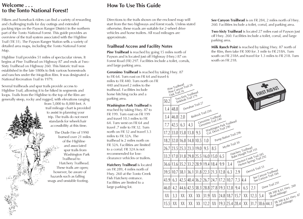
Overview
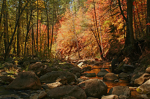
See Canyon Trail #184 is a beautiful alternative to Horton Creek crowds. See Canyon creeps up the east side of Promontory Butte from the Highline below the rim to FS 300 above the rim.
Note
As with all Mogollon Rim hikes, beware of the monsoon season. Storms break right off the rim above you. I have been drenched several times unexpectedly in this same area over the past several years.
Area
This is the far eastern section of the 54 mile Highline, which runs from Pine Trailhead, near the town of Pine, to 260 Trailhead. The Highline stretch from See Canyon east to Two-Sixty Trailhead is the best mountain biking I've experienced. I remember great rides and terrible flash storms. You can go from sweating to freezing in minutes.
Hike
Back to our task, day hiking! After all, it's much easier on the knees. The trail crosses Christopher Creek right away then takes on a nice grassy lined path. Fishing is very common where you cross Christopher Creek. The fish, whatever they are, can be seen swimming. I chased one upstream, trying to get a picture but was unsuccessful. It's was pretty cool. Just when I thought I had one cornered by a cascade, it jumped the cascade going up, which scared the crap out of me, nearly losing five grand in camera and computer equipment. On this May morning, it was much cooler than expected. I set a fast pace to generate some heat quickly. Once again, I was sweating and freezing at the same time. I have been in this area numerous times, and this always seems to be the case. See Canyon being on the east of Promontory Butte gets less afternoon sun making for chilly mornings.
Near the mile mark, you come to the junction with See Canyon Spring. I suggest taking this spur trail on the return trip. It's a half-mile to See Spring. I enjoyed this section of the trail. You could save one mile and a half-hour by eliminating this section if your feeling tired on the return trip. Soon after the junction, two seeps cross the trail. It's muddy here, so be careful. The trail crosses the creek and starts to ascend more. Coming back to the creek, you lose some elevation as the trail drops back down to cross the creek again. The boulders get bigger, and the trail gets steeper, going up. Christopher Creek is mostly dry in the upper reaches. Several springs lye in the first mile and a half. See Spring is usually a good flow.
About three quarters or a half mile before FS 300, you encounter the trail's steepest section. Be careful not to slip off the edge. You might need to negotiate numerous fallen trees, depending on trail maintenance. On this trip I encountered a huge tree I couldn't even crawl over. Pay close attention to the chevrons near the top. The trail is more open and less defined. Rusty colored sandstone rocks line the trail. This is familiar terrain along the edge of the rim. You could have a second car up here to shuttle back. That would make this just a three-mile hike or four with the See Spring spur. Die-hards could hide a mountain bike. There is another trail to the east, which is possible to descend on a bike. (that's the Drew Trail! now on-line! 07/19/01)
Head back down. Take the See Spring spur trail if you have the energy. The spring surfaces twice. A smaller spring is closer and spurs off to the left. The main spring comes out of the rocks. Mosquitoes swarmed me, and I missed the picture.
WARNING! Hiking and outdoor related sports can be dangerous. Be responsible and prepare for the trip. Study the area you are entering and plan accordingly. Dress for the current and unexpected weather changes. Take plenty of water. Never go alone. Make an itinerary with your plan(s), route(s), destination(s) and expected return time. Give your itinerary to trusted family and/or friends.
Permit $$
None
Directions
Road
FR / Dirt Road / Gravel - Car Okay
To See Canyon Trailhead In 2003 SR260 started bypassing the community of Christopher Creek. Member Trishness kindly updated the directions to the following:
From Phoenix: Take 87 N to 260 East and follow 260 for about 21 miles. Between mile marker 274 and 275 there is a huge green sign that says Christopher Creek. Turn left here and follow this road past a few small businesses (about 1/2 mile or so) and take a left onto FR284. This is a well maintained dirt road. Follow this for two miles to it's terminus. There is a huge parking area with restroom facilities.
Nan adds: FR284 is directly across the road from the Market in Christopher Creek, on the west side of the road.
From PHX (I-10 & AZ-51) 112 - 2 hours 51 mins From TUC (Jct 1-10 & Grant) 210 mi - 4 hours 18 mins From FLG (Jct I-17 & I-40) 136 mi - about 3 hours 4 mins
 Route Editor

 Overview