Route Editor

| Guide | ♦ | 3 Triplogs | 0 Topics |
details | drive | permit | forecast | map |
stats |
photos | triplogs | topics | location |
| 73 | 3 | 0 |
Canyons are inherently risky. Flash floods occur without notice on sunny days. Technical skills & surrounding topography knowledge required yet does not eliminate risk.
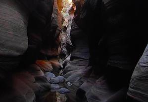
Subterranean, though not submariner by nonot This canyon may be 3BII in the summer taking 3-5 hrs (or part of a 3BIII/3BIV trip with the subway taking 8-10 hrs). However in early spring with snowmelt causing the canyon to flow, it is 4C conditions and is MUCH more dangerous.
Warning: Canyoneering involves travelling through slot canyons, always check the weather and do not go if there is any chance of rain. For this trip you need to bring appropriate gear including wetsuit/drysuit, 60 ft rope, helmet, harness, and rappelling device, 20 ft of webbing and a few quick links, and a GPS. You will need a special permit to do this hike. You will also need a subway permit should you intend to continue down canyon rather than just doing Das Boot. History: Named by Pitney after he descended it in early winter. Partnering up with a random person, he found the individual resistant to wearing a wetsuit or any cold protection (with ice in the canyon in the winter!) The individual proceeded to become hypothermic in the canyon and lost his shoe (unaware he did so). The man survived and completed the canyon without permanent injury, except perhaps to his pride. Hence the name: "Das Boot" for the missing footwear. Hike: From Wildcat Canyon Trailhead take the Lava Point trail east, past the Hop Valley trail to the Northgate Peak Trail. Take the Northgate Peak Trail south for a few hundred feet to the marked route for the Subway. Take the left branching subway trail to the bottom of Russell Gulch. Cross Russell Gulch and ascend up the slickrock ramp leaving to the east of the subway trail. At the top of this ramp ascend a little higher onto the upper sandstone level, though you do not have to get to the white layer. Contour south and east, maintaining your elevation. when you come to a ridge in front of a major canyon descend the gentler looking gully to its west. Follow the gully down to its terminus above Das Boot. Contour along the canyon edge to the east until you find an easy way into the drainage. This may require one exposed class 2/3 move. In the canyon proceed downstream, with a few wades (or swims). The first rappel is rigged from a log and about 15 ft. In 2010 there is a large dead elk that makes this a bit more memorable. Shortly after this is another 15 ft rappel. Continue downcanyon in the tight, cold, dark narrows. A log jam or two may present difficulties, use your skill to dispatch them easily enough. Even during 100+ degree summer temperatures, the water is near freezing and you can see your breath in sections. A 20 ft downclimb is required at a drop with no anchor, use your down-climbing and stemming skills to dispatch this one. Further down canyon is a very cool obstacle I refer to as the "Washing Machine". Too soon the canyon ends with a 20 ft rappel over a nonkeeper pothole and swimmer as the canyon opens up to join with the Subway router. If you just are doing Das Boot exit up the Subway Route back to your car. Otherwise proceed onto doing the route "Subway from the Top." Water Sources: Nothing you'd want to drink. If doing Subway from the top there are nice springs a mile or so down canyon you could filter from. Camping: Permitted near the trailhead or along Lava Point trail.
Check out the Triplogs. Leave No Trace and +Add a Triplog after your canyon trip to support this local community. | |||||||||||||||||||||||||||||||||||||||||||||||||||||||||||||||||||||||||||||||||||||||||||||