Overview
The Flatiron is a 6-mile, 4-hour round-trip hike. Most hikers consider this to be a more difficult hike and rate it above average to outstanding. If switchbacks are your passion, this hike will show you the flip side. It's a push (almost a climb) to the top, but well worth it.
Hike
Park at the Siphon Draw Trailhead in Lost Dutchman State Park and head out on the trail. The first section is across the Discovery Trail. Next, it's up to the boundary between the State Park and the Superstition Wilderness.
Hiking is straightforward up the gentle meadow slope. After a mile, the trail turns to your left. A canyon opens up in front of you. This area viewed from a distance appears to be a continuous, non-porous mountain. Now you know the real story.
Continue hiking another quarter mile to the slick rock area. You will find a mini waterfall after a rainy night. I've seen a little water running even weeks after the last rain on several trips. Keep in mind this area is a wee bit scary with a wet surface. Be careful! The slick rock is the turnaround point for anybody in their right mind.
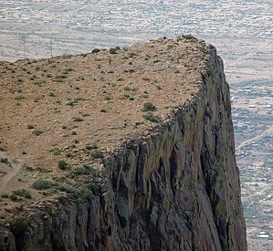
Okay, can you turn around here and miss all the fun? Not me! Continue up the canyon right of the waterfall area. When you return down this section, avoid going straight down. Pretend like there are switchbacks and zig-zag down the slope. Okay, continue following on up the wash. If you haven't figured out what the Flatiron is, it's that colossal mass looming over your head to the right.
After the waterfall section, you'll top out on a mini rise. There should be a canyon dropping out ahead and THREE vertical canyons leading to the top. Take the far-right canyon up to the Flatiron. Stay out of the other two canyons. There's a section or two requiring you to pull yourself up. Be careful not to go up to something you can't get down. Just before topping out is a ten-foot section nearly vertical. Other than that, there shouldn't be a lot of rock climbing. If so, you're off the trail. When you first top out on the ridge, get to know the area. The way back down can be hard to find if you lose orientation with the area. Follow the trail "that exists" to your right and around up to the tip of the Flatiron. The views are fantastic! The sheer drop-off is mind-boggling. Return down. You'll find it takes more concentration to come down. On your way home, look back at the Flatiron. It's hard to believe you hiked to the top!
Tip
Go after a wet winter in 70-degree weather for lovely desert flora.
Notice
Spray painting or permanently marking the route is defacing the wilderness. If you witness this type of illegal activity, report it to the Tonto National Forest (602) 225-5200.
WARNING! Hiking and outdoor related sports can be dangerous. Be responsible and prepare for the trip. Study the area you are entering and plan accordingly. Dress for the current and unexpected weather changes. Take plenty of water. Never go alone. Make an itinerary with your plan(s), route(s), destination(s) and expected return time. Give your itinerary to trusted family and/or friends.
Permit $$
AZ State Parks more info
2026 Day Use Fees range from $5–$30
Per vehicle (1 person): $10.00
Per vehicle (2-4 people): $20.00
Individual/bicycle: $5.00
$200 Annual Pass
Directions
Road
Paved - Car Okay
To Siphon Draw Trailhead From Mesa, follow Highway 60 East to Idaho Road. Turn North onto Idaho Road, which is SR88, and follow North 2.2 miles. SR88 bends right just past Scenic St. and Idaho continues North. Be sure to go right and stay on SR88. Follow SR88 4.9 miles to the Lost Dutchman State Park. Turn right into the park. Pay the fee, then follow the signs to the trailhead.
Free Alternative:
Utilize the Crosscut Trailhead 0.7 mi in on FR78. It is 2 miles on Jacobs Trail #58 to the junction with Siphon Draw #53. Which is 0.85 mi into #53.
2.00 - 0.85 = 1.15 mi extra each way
Mining Camp
This former free access point is now private as of Dec 2016.
2017 - cancel Christmas. It is closed.
From PHX (I-10 & AZ-51) 41.3 mi - about 52 mins From TUC (Jct 1-10 & Grant) 134 mi - about 2 hours 9 mins From FLG (Jct I-17 & I-40) 186 mi - about 2 hours 56 mins
 Route Editor

 Overview