Route Editor

| Guide | ♦ | 241 Triplogs | 4 Topics |
details | drive | permit | forecast | route |
stats |
photos | triplogs | topics | location |
| 541 | 241 | 4 |
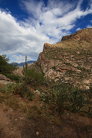
Flatiron of Tucson by fricknaley  I've been waiting for my dumb hamstring to heal well enough to climb Pusch Peak finally. I finally decided I no longer cared today and went for it. This hike is a blast. While it remains one of Tucson's most distinctive peaks (it is the western-most peak of Pusch Ridge jutting into Oro Valley), it seems to be a relatively well-kept secret. That or an unknown gem. Either way, this hike may be Tucson's answer to the Flatiron. A short, nasty screamer of a climb to a fabulous vista with views everywhere. Sounds cool, huh? I've been waiting for my dumb hamstring to heal well enough to climb Pusch Peak finally. I finally decided I no longer cared today and went for it. This hike is a blast. While it remains one of Tucson's most distinctive peaks (it is the western-most peak of Pusch Ridge jutting into Oro Valley), it seems to be a relatively well-kept secret. That or an unknown gem. Either way, this hike may be Tucson's answer to the Flatiron. A short, nasty screamer of a climb to a fabulous vista with views everywhere. Sounds cool, huh?At the trailhead, the trail splits, go left, and begin a leisurely climb up Pusch Ridge's foothills. You climb up typical Catalina Foothills desert here, all the while mocked by the peak. After about 10 minutes or so, the trail forks, go right and continue your easy climb. You come upon a drainage to your left, which you follow along for about 10-15 more minutes. As you can now see, there is a huge canyon feeding up into the northwest side of the peak, and this will be your route of attack. After about ½-¾ mile, the trail will switchback to your right, while a clear path also takes off to your left. Take this left. Immediately you see a rusted sign on your right marking the break off for the informal climb to Pusch Peak. Here we go.
There are two distinct trails east from this saddle. Take the lower one. The one at the saddle clearly heads up to the summit of the adjacent peak (avoid this one). The trail continues up from here, always climbing at a nearly ridiculous incline. We laughed at the audacity of the trail three-strong, as we climbed on a more easterly track towards the peak. Quite quickly, you cross the canyon wash and walk over to the east or left side of the prominent gulley you have been climbing. Now you hike away from this canyon as you can start to see where this trail is taking you. I must say all along, I was waiting for the trail to fade away to nothing basically, but it never really does. It climbs impossibly steep at times (many times actually), but it is always distinct. I should mention that all along, the views in front of and behind you are always wicked. As you keep going, a false summit ahead and slightly to your left is the goal. As you reach the false summit, you can finally see that the actual peak is not that far away. Puff those last crazy switchbacks, and you are there. A stunning 360 panorama awaits you at the top. There is a register for those who like. Take a breather and savor the climb, looking off to the east at Mt. Kimball and Mt. Lemmon. You have a knee breaking descent ahead of you on the way down, but it is so steep it goes by fast. Check out the Official Route and Triplogs. Note This is a moderately difficult hike. Leave No Trace and +Add a Triplog after your hike to support this local community. | ||||||||||||||||||||||||||||||||||||||||||||||||||||||||||||||||||||||||||||||||||||||||||||||||||||||||||||