Route Editor

| Guide | ♦ | 83 Triplogs | 2 Topics |
details | drive | permit | forecast | route |
stats |
photos | triplogs | topics | location |
| 2.1k | 83 | 2 |
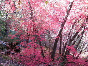
Awesome fall colors by CannondaleKid   Since a significant number of folks hiking in this area never reach where the actual "Bassett Peak Trail" begins, I figured it would be worth adding a hike description for the lower part of the trail. With various vegetation including sycamore, alder, maple, ash, oak, walnut, and aspen, it is well-known for a myriad of fall colors. Since a significant number of folks hiking in this area never reach where the actual "Bassett Peak Trail" begins, I figured it would be worth adding a hike description for the lower part of the trail. With various vegetation including sycamore, alder, maple, ash, oak, walnut, and aspen, it is well-known for a myriad of fall colors.Hike You begin hiking up the East Divide Trail #287, following the North Fork of Ash Creek from the trailhead. While much of it appears to be flat, the trail climbs a total of 1,000' with 400' of the gain coming in the first two miles. The trail then steepens a bit, and you'll climb another 600' over the next mile. Much of this part of the trail is heavily wooded, and you will criss-cross the creek numerous times along the way. At the crossings, you will enjoy a small amount of boulder-hopping.
Once you reach Upper Ash Springs, you will be amidst a stand of a few dozen aspens. The trickling water makes for a peaceful break before heading back down the trail. Due to the gradual climb on the way up, you may not realize just how much you climbed until to head back down. Your feet will feel much lighter than on the uphill hike, and one may almost feel refreshed as they continue down. The hardest part of this hike is knowing when the best fall colors will arrive. Unfortunately, this year we were a bit too soon., probably just over a week. Check out the Official Route and Triplogs. Leave No Trace and +Add a Triplog after your hike to support this local community. | ||||||||||||||||||||||||||||||||||||||||||||||||||||||||||||||||||||||||||||||||||||||||||||||||||||||||||||||||||||||||||||||||||||||||||||||||||||||||||||||||||||||||||||||||||