Route Editor

| Guide | ♦ | 20 Triplogs | 0 Topics |
details | drive | permit | forecast | 🔥 route |
stats |
photos | triplogs | topics | location |
| 526 | 20 | 0 |
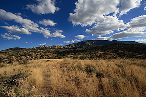
  History HistorySpud Rock - Outstanding point of bare rock in plain view from Tucson at the north end of the Rincons, elevation 8,590 feet. About 24 miles east of Tucson. George F. Kitt of Tucson says: "Two Southern Pacific railroad engineers, William H. Barnett and Jim Miller, had a shack here and raised potatoes and cabbage on a little flat close to the rock. They called it Spud Rock for their major crop --spuds. Barnett fell from his horse one day coming down the trail and was killed." Overview The Italian Spring Trail is possibly the least-used trailhead that provides direct access to the inner reaches of Saguaro National Park, West. This is despite the fact that it is one section of a journey that makes reaching the highest point in the Rincons in one day manageable. The entire course of the Italian Spring trail is marked by dated galvanized steel hashes nailed to, and sometimes, into; the trees along its course. The trail begins at the southwest bank of Tanque Verde wash near its confluence with a small stream bed that leaves White Tank near Redington road. The beginning of the trail is easy to spot as it lies within an obvious break in the trees. The sign here lets you know that you're on the Italian Springs Trail #95 and the NPS boundary is 4.5 miles away.
The trail beings to climb almost immediately, winding its way through desert grassland dominated by scrubby manzanita and mesquite. This section of the trail follows an old double-track jeep road and is fairly easy to follow as the grasses have not retaken the tracks. Large cairns mark some of the potentially tricky segments. After crossing the rolling foothills for about 2.2 miles, the trail drops into Tanque Verde wash once again and a barbed wire fence and old metal sign are encountered. This is the site of the original trailhead and the trail now passes into the Rincon Mountain Wilderness. The sign here states that the Park boundary is now 2.3 miles away. After leaving the wash, the trail begins to climb with a steeper grade. As the trail passes through the first of many small oak forests and then begins to take-up a steep ascent along a steep ridge. The trail is now flanked by hoodoos and large boulder and rocks formations that seem out of place as if they had been transplanted from the Chiricahua Wilderness. The track along this section of trail is gullied and washed out, sometimes severely, in many places. Trail finding is no issue, but maintaining footing is tricky in some spots. Many vista points exist along this section of trail offering sweeping views of the rock formations beyond. After roughly two miles the trail enters a section of oak forest and begins its final ascent into the National Park boundary. A metal gate is soon encountered and a sign-in roster sits just beyond. The signage here still refers to the area as the "Saguaro National Monument", a claim challenged by the Arizona Trail signs that announce the trail's entry to the National Park and state that Italian Spring is two miles ahead. After entering the Park, the trail takes a course through an area that was once an unmistakable oak woodland prior to being ravaged by fire. The trail continues to climb steeply, eventually reaching a series of stone steps and other improvements. This section of trail is deceptively steep, but offers amazing views of the Catalinas and Santa Teresas, in part because most of the overhead canopy was burned away long ago. The trail begins to show signs that it is winding its way west and over the head of Joquin canyon. Sweeping views of Tres Pipas canyon to the west give way to a pine-oak woodland that seems to have been partially spared from the inferno. Shortly thereafter the trail begins to level out to an extent and enters into a decidedly pine forest. The final section of the trail as it approaches Italian Spring is mostly forested and riparian. The trail approaches a junction with the North Slope and Fire Loop trails. Italian spring is on the right and is really just a seep that has been excavated in the forest floor creating a small pool. From here make a left and head south and UP on the North Slope trail. This zigzags up through needle-littered slopes of pine into the very high country of Mica Mountain. Great shade and fragrant pine-scented breezes ease your pain as you grind out those last 500-600 feet of climbing to hit the long southwest running ridgeline of Mica Mountain. This section of the North Slope trail is about 0.6 miles in length and runs through a mixed coniferous forest sprinkled with grass. The trail is easy to follow. After that 0.6 mile stretch you come to another signed intersection...the Fire Loop trail. The signage up here can be a little tricky. Here you will want to hang a right (I believe the sign actually says that Mica Mountain and Spud Rock are to your right). Follow this section of the Fire Loop trail up a little way more through spectacular pine country. In 0.2 miles the signed Bonita Trail will break off left at 8560 feet. Stay straight/right and keep on trucking. In other 0.15 miles, the signed Mica Meadow/Mica Mountain trail will break off left. Again, stay straight/right and keep on going just a couple of minutes to the signed summit of Mica Mountain heading in the pines at 8664 feet. The concrete foundation of an old building sits on the summit. There are no views at all, it is a very gradual summit. There's nothing subdued or gradual about your climb, though. You just climbed the tallest mountain in the Rincons and ground out 4600+ feet. Don't worry though, there is a prize for your suffering. We're gonna head to Spud Rock to get those views you came for. Continue on past Mica and actually start descending gradually through the trees.. feels kinda nice. The Fire Loop trail will take you right to Spud Rock too, it's only about 0.4 miles from the Mica Mountain summit. It also passes through some spectacular oaks along the way that will seem almost electric in fall. Just before Spud Rock another trail breaks left (the Spud Rock trail). At the base of Spud Rock, a sign announces its presence and points you right up a short use path spur to climb to the summit of Spud Rock. This last climb is less than a 100 feet, it feels like 100 miles...but trust us folks, it's worth it. Dazzling 360-degree views await at the top of Spud. The Catalinas in all their glory north. Looking west you have Tanque Verde Peak right in front of you, with the Tucson Mountains, Babo, and Kitt Peak further out. South presents Rincon Peak in the near-ground and Wrightson and the Santa Ritas further out. Looking east you have Mica. Due north are really neat views out over the foothills and scrublands/forest service roads of the Redington area. It's really worth the trip for this view. Spud Rock sits at 8613 feet and roughly 8.15 miles from the car. Head back the way you came. As an alternative, you can keep heading west on the Fire Loop Trail and make a couple of rights at the intersection with the Cow Head Saddle trail to loop back to the Italian Springs trail on the North Slope trail, but you can see from Spud Rock that this loop will take you through a pretty heavily burned area, and I once read that this section of North Slope was hit pretty hard in the fire. Heading back the way you came is a little shorter, but more importantly, takes you through that sweet pine forest again. Gate Policy: If a gate is closed upon arrival, leave it closed after you go through. If it is open, leave it open. Leaving a closed gate open may put cattle in danger. Closing an open gate may cut them off from water. Please be respectful, leave gates as found. The exception is signage on the gate directing you otherwise.
Check out the Official Route and Triplogs. Note This is a more difficult hike. It would be unwise to attempt this without prior experience hiking. Leave No Trace and +Add a Triplog after your hike to support this local community. | |||||||||||||||||||||||||||||||||||||||||||||||||||||||||||||||||||||||||||||||||||||||||||||||||||||||||||||||||||||||||||||||||||||||||||||||||||||||||||||||||||||||||||||||||||||||||||||||||||||||||||||||||||||||||||||