Route Editor

| Guide | ♦ | 30 Triplogs | 4 Topics |
details | drive | no permit | forecast | map |
stats |
photos | triplogs | topics | location |
| 260 | 30 | 4 |
 Camping CampingMogollon Rim Campgrounds ( map ) Blue Ridge Campground Moqui Group Campground Rock Crossing Campground In addition to the above designated sites dispersed camping is permitted around the lake. Please read and follow the guidelines. Do not cross any private land, which is typically well marked in the area.
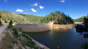
While this page is listed as kayaking you may post a triplog and change the mode of travel to suit. Hiking down to the backside of the dam for instance is a nice little hike. The following hikes are not marked well if at all. They are short enough most can find their way. Take a GPS or our GPS App to find your way back if concerned. Rock Crossing Trail #18A Rock Crossing Trail #18B Rock Crossing Trail #18C History - 1963 The 190 foot high dam is a thin-arch double-curvature dam. It is the thinnest for it's height. The arch is 14 feet at the bottom and 6 feet wide at the top. The dam is 160 feet wide at the bottom and fans out to 460 feet at the top. Morrison Knudsen Construction spear headed the $6 million project for Phelps Dodge Corp. Concrete for the dam first poured on July 23rd and is expected complete on Dec 20th. A tunnel with a 30 foot drop over 8 miles through the Mogollon Rim will provide gravity flow into the East Verde River. The 44,000 foot tunnel is expected to be completed in Feb 1965. A one of it's kind 80 inch diameter and 32 foot long boring machine is used. It thrust 600,000 lbs forward and a million pounds against the walls. 100 feet of water in the lake is required to push through the 18 inch pipe. Better fishing is anticipated. History - 1967 This is the lake that copper built. Phelps Dodge Corporation needed water for the Morenci Mine. The Salt River Project had rights to the nearby Black River. So Phelps built the Ridge Dam where it owned water rights. They diverted East Clear Creek flow from the Colorado River to the East Verde for Valley use in exchange for Black River water. History - 2011 The reservoir is set to lose it's beloved cool pine forest name. Check out the HAZ Forum topic. VV Mystery The tangled VV web
Check out the Triplogs. Leave No Trace and +Add a Triplog after your kayak trip to support this local community. | ||||||||||||||||||||||||||||||||||||||||||||||||||||||||||||||