Route Editor

| Guide | ♦ | 11 Triplogs | 0 Topics |
details | drive | no permit | forecast | 🔥 route |
stats |
photos | triplogs | topics | location |
| 146 | 11 | 0 |
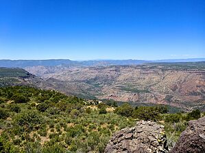
Backdoor to Fossil Springs by John10s  Overview Nash Point (6,546'), located northwest of Strawberry, AZ, overlooks the Fossil Springs Wilderness to the west and offers beautiful views of the surrounding canyons and the distant San Francisco Peaks. The hike starts just off Highway 260 and follows a forest road for about two and a half miles near the edge of the Mogollon Rim, ending with a short scramble up to a scenic rock outcropping at Nash Point. History Like the nearby Nash Pasture Trail, Nash Point is named for Lafayette P. Nash, who was born in Ohio and eventually settled in Phoenix in 1870. Nash was involved in prospecting, mining, and various business ventures around the state. He also served in several government positions in Arizona, including a stint as Justice of the Peace in Miami and a term in the Territorial Legislature.
The route begins from a spacious dirt parking lot on the west side of Highway 260. Pass through the wire gate to start following FR 9365R. After about a half mile, a road branches off to the left toward a quarry; continue right to stay on 9635R. You'll pass several electrical access panels, possibly associated with the quarry, as well as assorted trash that, unfortunately, is plentiful in this area. A quarter mile past this intersection, Nash Tank appears on the north side of the road. Beyond the tank, the road gradually loses ~300 feet of elevation over the next mile and a quarter. Despite the generally easy route finding following the road, multiple small jeep roads branch off FR 9365R at various points along the way, and the lack of signs at the intersections makes the correct route less obvious in some areas, so the GPS track can come in handy. Around two miles in, the road begins a gradual climb, regaining most of that 300 feet of lost elevation on the approach to Nash Point. The forest road eventually deteriorates into an ATV track that leads nearly all the way to the base of the rock outcropping. The scramble up to the top is straightforward, though there are some gaps and large cracks in the rocks to avoid. Once on top, look north to see the San Francisco Peaks and Kendrick Peak on the horizon. Closer in, to the north/northeast, you can see the red cliffs above Fossil Creek and into Calf Pen and Sandrock Canyons. To the west, you'll have impressive views overlooking the Fossil Springs Wilderness. After enjoying the surroundings, you can scramble down and return to the parking lot via the same route along FR 9365R. If you're looking for a longer outing, Nash Point provides a good starting point for an alternate access point to the Fossil Creek Wilderness and Bob Bear Trail #18. Along the route to Nash Point, you can use some of the other jeep roads to connect with Nash Pasture Trail, a steep, loose, and unmaintained route that intersects Bob Bear Trail. Check out the triplogs for more details. Another nearby option is Vine Canyon Loop, a challenging off-trail route that starts from the same parking lot as Nash Point. Gate Policy: If a gate is closed upon arrival, leave it closed after you go through. If it is open, leave it open. Leaving a closed gate open may put cattle in danger. Closing an open gate may cut them off from water. Please be respectful, leave gates as found. The exception is signage on the gate directing you otherwise. Check out the Official Route and Triplogs. Leave No Trace and +Add a Triplog after your hike to support this local community. | ||||||||||||||||||||||||||||||||||||||||||||||||||||||||||||||||||||||||||||||||||||||||||||||||||||||||||||||||||||||||||||||||||||||||||||||||||||||||||||||||||||||||||||||||||||||