Route Editor

| Guide | ♦ | 385 Triplogs | 32 Topics |
details | drive | permit | forecast | 🔥 route |
stats |
photos | triplogs | topics | location |
| 2.3k | 385 | 32 |
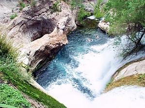
Extraordinary, lush, green! by Dakota   Warning WarningThe difficulty rating is for "in-season". There is very little shade on this trail. 90+° 8am - 6pm kills History The creek is heavily charged with minerals. Objects such as twigs falling into the stream are quickly coated with travertine layers, hence Fossil Creek's name. Permit April 1st to Oct 1st, view permit info.
Fossil Springs is a gorgeous riparian area with springs spilling out of the earth everywhere. There are large pools of crystal clear water in several places that invite you to swim. Fern and lush green moss grow randomly everywhere. Once you are in the heart of Fossil Springs, you will never believe that you are still in Arizona, and you will not want to leave! Hike The trail down is wide and very easy as it was once an old road but is now closed to vehicles. The beginning of the trail is mostly desert; as you descend into the canyon, the vegetation changes until you are finally amongst tall Sycamore trees, Oak trees, fern grotto, and wild blackberry bushes. Once you reach the canyon's bottom, you will reach a streambed, and the trail then becomes a footpath. Follow it to the west. Fossil Creek is one of the most reliable, abundant water sources in Northern Arizona and has been used since 1916 to generate hydroelectric power. Rumor has it that Irving Plant is about to be shut down, in which case the roads to Fossil Springs probably will not be maintained. It is 2.76 miles just to the mouth of Fossil Springs, then another 5 miles until you hit Irving Power Plant. Depending on how much you want to explore will determine the length of your trip. Just be sure to leave ample time for your steady climb back UP! I find that is the part I hate! I have also encountered several people who head back up the trail with not nearly enough water - you will need a lot of energy for this hike back out. It is the most challenging part of the whole hike! An excellent shuttle trip would be to go down the east side and out the Flume Rd. Whatever your choice is, make sure you take most of the time just to enjoy the sounds of the springs and the feel of the clean, crisp water. As I mentioned in the beginning, I was here before it became popular, and it was pristine! I camped there for four nights and didn't see a soul all weekend. The past few times I have been there, I have run into boy scouts, large church groups, and people everywhere. I saw a lot of trash lying around, and had an ugly confrontation with a Boy Scout and his leader because the boy scout was trekking out with a turtle that he decided he wanted to take home to his aquarium - the leader thought this was ok. Needless to say, through several phone calls, I went all the way to the regional president of the Western Boy Scouts division to complain. Not sure what good it did to the turtle taken from his home, but hopefully, people will learn to respect nature. Years ago before anyone knew about Fossil Springs I backpacked in via the Flume Rd. It was a longer way to get into the Springs, but much more level and flat. But a quicker route into Fossil Springs is the trailhead to the east - directions below. If you choose to go in from this side, remember that the climb down is also the climb back up!
Check out the Official Route and Triplogs. Leave No Trace and +Add a Triplog after your hike to support this local community. | |||||||||||||||||||||||||||||||||||||||||||||||||||||||||||||||||||||||||||||||||||||||||||||||||||||||||||||||||||||||||||||||||||||||||||||||||||||||||||||||||||||||||||||||||||||||||||||||||||||||