username
X
password
register
for free!
help


Mount Fagan East, AZ

Guide 12 Triplogs  0 Topics
  3.3 of 5  
Fav
Wish
3
details
drive
permit
forecast
route  
stats
photos
triplogs
topics
location
70 12 0
Statistics
tap row or icons for details
Difficulty 3 of 5
Route Finding 2 of 5
Distance Round Trip 2.46 miles
Trailhead Elevation 4,053 feet
Elevation Gain 1,112 feet
Accumulated Gain 1,314 feet
Avg Time Round Trip 3.5 hours
Kokopelli Seeds 9.03
 Interest Off-Trail Hiking & Peak
 Backpack Possible - Not Popular
unreported if dogs are allowed
editedit > ops > dogs to adjust
feature photo
Photos Viewed All MineFollowing
Inaugural Calculation on Button Tap!
2  2025-01-18
East Fagan Foothills 5102
pseudalpine
19  2024-01-05 DixieFlyer
6  2022-02-07 thomasholtward
14  2019-02-07 markthurman53
14  2017-04-22 AZHiker456
9  2009-01-17 PhilipMueller
6  2002-12-09 rwstorm
Author
author avatar Guides 59
Routes 1,100
Photos 1,191
Trips 1,290 map ( 9,859 miles )
Age Male Gender
Location Arizona
Associated Areas
list map done
Tucson Region
Historical Weather
Trailhead Forecast
Radar Map
Expand Map
Preferred Nov, Dec, Mar, Apr → 7 AM
Seasons   Autumn to Spring
Sun  6:00am - 6:43pm
Official Route & 7 Rts
 
0 Alternative


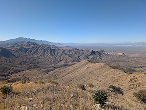
Northern Tier of the Santa Rita
by pseudalpine

 
Overview
Obviously, several approach options are possible to summit peak 6189. This guide describes a decent route from the east side of Mount Fagan. Two other approaches are: 1) from the south via Helvetia Road near McCleary Canyon or 2) a shorter option (legality unknown) from the northwest via Houghton Road and East Ocotillo Rim Trail.


Hike
Northwest of the 5102 turnabout is a spur road that descends steeply west to another turnabout. From this salt lick saddle, faint game trails crisscross the east-facing hillside below 5420. Link the least resistive paths, steeply ascending the grassy and rocky slope aiming for the south side of 5420. There are a few trees here and there as another saddle is crossed to gain the northeastern ridgeline of Mount Fagan. The track becomes mostly easier to follow and isn't as steep for the rest of this final scenic section to the summit.
remove free decal offer
Synopsis
Stats for the official route are roundtrip from the Lake Road (FR 2862). A trip will probably be more mileage and AEG as listed since most hikers will start from various points along the East Fagan Foothills 5102 loop depending on their mood and/or vehicle capabilities.

2025-01-21 pseudalpine


    Check out the Official Route and Triplogs.
    Leave No Trace and +Add a Triplog after your hike to support this local community.
    WARNING! Hiking and outdoor related sports can be dangerous. Be responsible and prepare for the trip. Study the area you are entering and plan accordingly. Dress for the current and unexpected weather changes. Take plenty of water. Never go alone. Make an itinerary with your plan(s), route(s), destination(s) and expected return time. Give your itinerary to trusted family and/or friends.

     Permit $$
    None

    Coronado Forest
    MVUMs are rarely necessary to review unless mentioned in the description or directions
    Coronado Motor Vehicle Use Maps (MVUMs)


     Directions
    or
     Road
    FR / Dirt Road / Gravel - Car Okay

    To hike
    NA: Connector trail.
     90+° 8am - 6pm kills
    helpcorrectionissue

    end of page marker