Route Editor

| Guide | ♦ | 10 Triplogs | 2 Topics |
details | drive | permit | forecast | route |
stats |
photos | triplogs | topics | location |
| 115 | 10 | 2 |
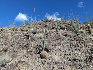
Sheer Ephemeral Rim to River Route by pseudalpine   Overview OverviewA brief hike that utilizes the Vulcans Throne lava flow remnants for access to one of Grand Canyon's colossal rapids. This will be a challenging, but fugacious trek for anyone who's well-equipped, relatively fit, has fundamental route-finding skills, and completes it during an optimal weather window. It'll likely be agonizing, perhaps hellish, maybe torturous, and quite possibly lead to your death otherwise. Warning Don't be like Victor!
From the limited car park, the route follows the sandy wash south to the edge of a lava cliff. It's possible to bypass this first escarpment on either side, but west (right) is easier and doesn't require any scrambling. There are signs of an old, steep road dropping into a hanging valley. Follow this down into a series of coarse talus ravines that do have a bit of early morning cliff shade. After this section, the route is seriously exposed to the sun, even steeper, and guess what? More abrupt loose lava scree. Eventually one will gain a sloping ridge that is formed by an angling lava dike. The west (right) side of this ridge is rockier, but the trail diminishes until further down on yet another steep ridge. A well-cairned path reemerges through some Ocotillo ledges and a small wall scramble, then meanders down to a ravine and small col. Past this point over this saddle and right, it's very loose, precipitous scree skiing until reaching the riverbank. Along the Colorado River, a sandy, occasionally bouldery trail is present that leads to the beach where river parties stop to downstream scout the falls from the black boulder overlook. Synopsis A powerful and memorizing rapid that's extremely enjoyable to loiter at for a while. It can also be quite entertaining watching boats getting dump-trucked and the river party members being joggled through the lower cheese grater. It's obvious how people who've hiked here could protract their stay, underestimate the ascent ahead of them, become dehydrated, and get themselves into some vexing trouble.
Check out the Official Route and Triplogs. Leave No Trace and +Add a Triplog after your hike to support this local community. | |||||||||||||||||||||||||||||||||||||||||||||||||||||||||||||||||||||||||||||||||||||