 Route Editor

| Guide | ♦ | 112 Triplogs | 0 Topics |
details | drive | permit | forecast | 🔥 route |
stats |
photos | triplogs | topics | location |
| 312 | 112 | 0 |
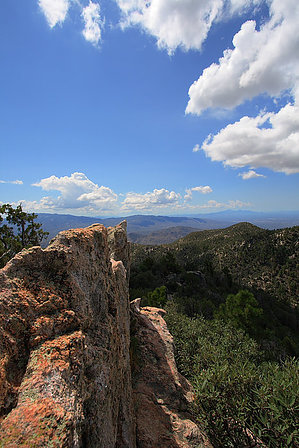
Woody's Revenge by fricknaley   I've walked right by the takeoff to Guthrie Mountain many times on my trips along the Green Mountain trail. I've always thought, "I'll do that next time". I should have done it sooner because this turns out to be a fun little-known peak to bag in the Catalinas. Sitting at roughly 7281 feet, Guthrie does not see many visitors though it is undoubtedly worthy. There is even a nice little trail that runs out to its summit. You can start this hike from either end of the Green Mountain trail, the lower General Hitchcock campground, or the upper Green Mountain trailhead at milepost 18. This description will be from the upper trailhead since it is higher in elevation and slightly cooler this time of year. I've walked right by the takeoff to Guthrie Mountain many times on my trips along the Green Mountain trail. I've always thought, "I'll do that next time". I should have done it sooner because this turns out to be a fun little-known peak to bag in the Catalinas. Sitting at roughly 7281 feet, Guthrie does not see many visitors though it is undoubtedly worthy. There is even a nice little trail that runs out to its summit. You can start this hike from either end of the Green Mountain trail, the lower General Hitchcock campground, or the upper Green Mountain trailhead at milepost 18. This description will be from the upper trailhead since it is higher in elevation and slightly cooler this time of year.The Green Mountain Trail #21 is fully described on HAZ, and I refer you to that guide for details. Briefly, the Green Mountain Trail takes off from the Catalina Highway and runs mostly east and south, offering different Catalina views than what most are used to. It descends nearly the whole way, so you gotta climb on the way back. There are areas along the way that the forest burned in the fires, and the recovery process is underway. The trail is always easy to follow. Along the way, there will be two signed takeoff points for the Brush Corral Trail #19, at roughly 0.2 miles and 1.2 miles from the trailhead. Just follow the route of Green Mountain. There are frequent views north and east, which tend to be very long.
Jump on the path to Guthrie Mountain. I was surprised, it is pretty easy to follow. There are cairns present too, though they are not necessary. There is a lot of interesting red rock on Guthrie, and I'm not sure why. The route to the peak is about 1 mile in total. The path climbs to the ridge and runs it for a while, offering you views of your goal. It then descends a small saddle before climbing back up to the summit proper. It's a decent little climb. The last part of the climb before the top is a little exposed up some slick red-colored rock. It's a very short segment, though, then up to the forested summit. If you scramble around, you can climb up some boulders and get outstanding views of the eastern Catalinas, as well as north. Not the typical stuff I'm used to seeing up here. Worth it just for that. To get back, retrace your steps and remember that there is some good climbing to do on the way back. Check out the Official Route and Triplogs. Leave No Trace and +Add a Triplog after your hike to support this local community. | |||||||||||||||||||||||||||||||||||||||||||||||||||||||||||||||||||||||||||||||||||||||||||||||||||||||||||||||


