Route Editor

| Guide | ♦ | 15 Triplogs | 1 Topic |
details | drive | permit | forecast | route |
stats |
photos | triplogs | topic | location |
| 179 | 15 | 1 |
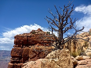
Finders keepers! by chumley  Overview OverviewCardenas Butte is one of two prominent summits just west of the Tanner Trail below the eastern Grand Canyon's Lipan Point (Escalante Butte being the other). It is accessed by descending 2000 feet along 2.5 miles of the Tanner Trail before scrambling off-trail for half a mile up a steep ridge to the peak nearly 700 feet above you. History García López de Cárdenas was a Spanish Conquistador under Francisco Vasquez de Coronado and is credited with being the first European explorer to "discover" the Grand Canyon after first seeing it in 1540 while on an expedition in search of the mythical Seven Cities of Gold (Cíbola). After three days of attempts to reach the river, he and his party were forced to retreat because they were low on supplies and water. It was three centuries later before the next known Europeans happened upon the Grand Canyon!
Begin this hike from the Lipan Point trailhead, descending on the mostly-unmaintained Tanner Trail. Tanner is steep and loose, and descending 1500 feet in the first mile is slow-going. Think about it as you descend because you'll be returning up in a couple of hours! As you descend, nice views of both Escalante and Cardenas Buttes present themselves before you. Once reaching the saddle between Tanner Canyon to the east and Seventyfive Mile Canyon to the west, Tanner levels considerably. A moderate pace can be attained when rounding the eastern base of Escalante Butte and continuing around the wide drainage between Escalante and Cardenas. At about the 2.75 mile mark, you will reach a well-defined ridge that climbs the southeast slope of Cardenas Butte. There are no cairns and no visible signs of use. But at this point, leave Tanner and begin the 675-foot ascent to the top of Cardenas Butte. The route takes you through a series of "steps" as you ascend through the multiple layers of the Supai Group. None presents too much of a challenge, but each requires a bit of a scramble, and you will use your hands. About 150-feet below the summit, you reach a lower peak and proceed north across the saddle toward the ultimate goal. Here you cross a somewhat narrow neck, with a very steep, exposed, scree-filled chute leading west down toward the dry Cardenas Creek, with expansive views of the canyon and the vertical western face of Cardenas Butte. The obvious route is to stay to the east, and here a bit of route-finding will be necessary to find the easiest way up the final ascent. After proceeding along the eastern side of the butte about half the distance of the butte, there are a couple of routes that can be climbed with no need for technical gear. From there, the peak is a short scramble farther up, and the views here are some of the best you'll find anywhere. You can return to the trailhead the way you came, or from the lower peak south of the butte, you can follow the ridgeline to the southwest and summit Cardenas Butte's bigger brother Escalante Butte! Warning This route involves off-trail scrambling and requires the use of hands, on some portions. This route should only be attempted by hikers who are comfortable and experienced hiking off-trail in the Grand Canyon or other desert locales. There is no water on this route and no shade. It should not be attempted during hot weather. Check out the Official Route and Triplogs. Leave No Trace and +Add a Triplog after your hike to support this local community. | |||||||||||||||||||||||||||||||||||||||||||||||||||||||||||||||||||||||||||||||||||||