Route Editor

| Guide | ♦ | 12 Triplogs | 1 Topic |
details | drive | permit | forecast | route |
stats |
photos | triplogs | topic | location |
| 320 | 12 | 1 |
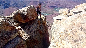
Rising to the top! by chumley  Overview OverviewEscalante Butte is the highest of several summits west of the Tanner Trail at the eastern end of the Grand Canyon. Its distinctive white peak is capped with Coconino Sandstone and sets it apart from its lower neighbors, most notably the nearby Cardenas Butte. Gaining this summit requires off-trail scrambling and some short non-technical climbs. The peak itself is split by a wide crack that requires an exposed leap to reach the high point. History The butte gains its name from the Franciscan priest Silvestre Vélez de Escalante. He joined Francisco Atanasio Domínguez in an expedition in search of an overland route from Santa Fe to California in 1776. Unfortunately, the Dominguez-Escalante Expedition failed to reach California after traversing southern Colorado and Utah but returned to Santa Fe via northern Arizona. As far as I can tell, Escalante never actually saw the Grand Canyon, having been warned away from it by Native Americans who told them they would not be able to cross it.
Getting to Escalante Butte first requires you to descend the Tanner Trail from Lipan Point. The first mile of Tanner drops 1500 feet on a largely unmaintained trail that features loose footing and is slow going. During the descent, Escalante is in full view and gives you a chance to look for a good route if you choose to ascend from the south. When you reach the saddle between Tanner Canyon to the east and Seventy-five Mile Canyon to the west, Escalante looms directly in front of you, 885-feet up. Depending on your level of adventure, you can leave the Tanner trail here and make your ascent toward the peak. The route is more difficult, and large shelves of the Supai Group present some climbing challenges that might require some traversing to find the best climbs. It is possible to climb the south side of Escalante from the saddle, but it is not the easiest route, and I think the best option is to stay on Tanner and ascend from the north side instead. As the Tanner trail passes around the base of Escalante on the east, you might also be tempted to climb this east ridge to the peak. This is also possible, and the more moderate slope of this ridgeline would be preferred over the south slope, but again, the terrain is more challenging than the north side. So, stay on Tanner as it rounds the butte and turns to the west, following it until it turns north again toward Cardenas. It is the saddle between Escalante and Cardenas that is the ideal starting point for the ascent. Resist the temptation to leave Tanner too early. The northeast slope of Escalante has a lot of vegetation that makes the climb more difficult. Instead, stay on Tanner for 2.25 miles before turning west and hiking off-trail up toward the saddle. There is no marked route here, but you may see footsteps and signs of other use. When you reach the saddle, turn toward the south and begin the ascent to the summit. Here there are occasional cairns and signs of use, but nothing that resembles an established route. The easy off-trail scramble turns into a big boulder-hopping adventure when you reach the prominent white sandstone boulders that make up the top of the butte. When you reach the summit, you'll find the easiest route to the high-point is to go through a "cave" between huge sandstone slabs before turning back toward the peak. At this point, you will realize that the peak consists of two enormous slabs of rock, separated by a 3-foot crack. The western slab is slightly lower, but is easy to climb due to it's slant. The eastern slab is the high point but can't be climbed safely without gear. So in order to reach the true summit, you must jump from the western slab to the eastern slab. While the distance should make it simple, the exposure will get in your head. Whether you make it to the east slab or not, the views are spectacular and worth the trip even if you choose not to make the leap. When heading down, you can re-trace your steps and descend the north slope, or you can save some mileage (but probably no time) by cutting the corner and descending the south or east slopes. There are some drop-offs in the Supai that will require traverses, so the recommended route is either back to the north or following the east ridge. Once again on Tanner, it's just a long grueling climb back to Lipan. Caution This hike features off-trail scrambling and requires you to use your hands to climb in some sections. Only experienced and comfortable off-trail in the Grand Canyon or other desert locales hikers should attempt this route. There is no water or shade in this part of the canyon, and hiking here during hot days is not recommended. Check out the Official Route and Triplogs. Leave No Trace and +Add a Triplog after your hike to support this local community. | ||||||||||||||||||||||||||||||||||||||||||||||||||||||||||||||||||||||||||||||||||||||||||||||||||||||||||||||||||||||||||||||||||||||||||||||||||||||||||||||||||||||||||||||||||||