username
X
password
register
for free!
help


Scheurman Mountain, AZ

Guide 5 Triplogs  1 Topic
  2.3 of 5  
Fav
Wish
3
details
drive
permit
forecast
map
stats
photos
triplogs
topic
location
46 5 1
Statistics
tap row or icons for details
Difficulty 2 of 5
Route Finding 1 of 5
Distance Round Trip 4.5 miles
Trailhead Elevation 4,085 feet
Elevation Gain 670 feet
Accumulated Gain 670 feet
Avg Time Round Trip 2.5 hours
Kokopelli Seeds 7.85
feature photo
Photos Viewed All MineFollowing
24  2024-09-29 mt98dew
5  2014-12-07 boneboyj
2  2011-04-21 roverfish
4  2007-02-18 slegal
11  2001-04-14 joebartels
Author
author avatar Guides 264
Routes 2,797
Photos 14,494
Trips 5,894 map ( 29,783 miles )
Age 55 Male Gender
Location
Associated Areas
list map done
Sedona Region
Historical Weather
Trailhead Forecast
Expand Map
Preferred Mar, Nov, Apr, Feb → 7 AM
Seasons   Early Autumn to Late Spring
Sun  6:04am - 6:47pm
0 Route
 
0 Alternative


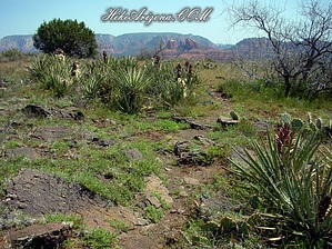
Definitive exponential of drab
by joebartels

 
On the north side of Scheurman Mountain is SR 89A. "Upper Red Rock Loop Road" loops around the east side. "Lower Red Rock Loop Road" continues up on the west side of Scheurman Mountain. Sedona High School sits on the northeast end.


Scheurman Mountain isn't a big Sedona attraction. It's relatively unexciting in itself, wide and flat. There are no exotic peaks or red rock formations. The trail crosses from the southwest end to the northeast end right next to the high school. "Sedona Hikes" suggest the high school end to be more worthy of a visit than the southwest end. I'm just going to say it's all a little drab at best. Hiking the trail did give me a better understanding of the area. The trail is labeled as the "S" trail on forest service markers. It's apparently a horse trail used by the surrounding community. I can see this as a fair ride if you lived nearby. However, I wouldn't recommend going out of your way to reach this trail. It's peaceful on top with long stretches that are relatively flat and barren. Views tend to be distant. A few spur trails take off along the way. None of which add much to the experience.
remove free decal offer
The trail can be accessed from either end. I choose the southwest end to hook up with the SRA Gooseneck Hike. It's unlikely you'll want to hike the whole mountain back and forth for 4.5 miles. You might want to pick up a quick view from either end and go right back down. The top might be nice with broken clouds and a cool breeze.

2001-04-14 joebartels
  • 2021 Verde Valley Trails
    region related
    2021 Verde Valley Trails
  • 2021 Verde Valley Area
    region related
    2021 Verde Valley Area
  • 2021 Sedona Trails Map
    region related
    2021 Sedona Trails Map


Check out the Triplogs.
Leave No Trace and +Add a Triplog after your hike to support this local community.
WARNING! Hiking and outdoor related sports can be dangerous. Be responsible and prepare for the trip. Study the area you are entering and plan accordingly. Dress for the current and unexpected weather changes. Take plenty of water. Never go alone. Make an itinerary with your plan(s), route(s), destination(s) and expected return time. Give your itinerary to trusted family and/or friends.

 Permit $$
Red Rock Pass - may or may not be required. Go to Red Rock Pass then check "When is a Red Rock Pass Required?". If you have questions contact the Coconino forest service.


 Directions
or
 Road
Paved - Car Okay

To hike
From the Sedona 'Y' ( 179/89A ) go west (what seems like South) on 89A 5.4 miles to Lower Red Rock Loop. Turn left onto Lower Red Rock Loop (this seems to be a speed zone so be careful turning) and follow 1.8 miles to the wide shoulder on the right just before a retaining rail. There's room for about 3 - 4 vehicles. To reach the trail walk back on the road (the way you came) for about a tenth of a mile. The trail takes off on the right side of the road going up immediately. The SRA Gooseneck Trail takes off across the road on the side you parked on.

The northeast trailhead can be accessed off Scorpion Way near the high school.
 90+° 8am - 6pm kills
helpcorrectionissue

end of page marker