Route Editor

| Guide | ♦ | 1 Triplog | 0 Topics |
details | drive | permit | forecast | route |
stats |
photos | triplog | topics | location |
| 6 | 1 | 0 |
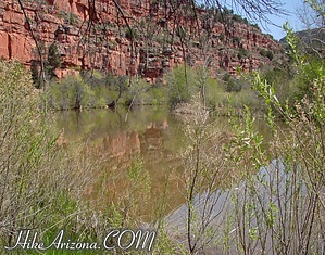
No Geese! by joebartels   This hike takes you to a tight bend in Oak Creek southwest of Scheurman Mountain. The hike is made up of three horse trails. Wanna guess? Yep, the "S" trail followed by the "R" trail and continuing on the "A" trail. This hike takes you to a tight bend in Oak Creek southwest of Scheurman Mountain. The hike is made up of three horse trails. Wanna guess? Yep, the "S" trail followed by the "R" trail and continuing on the "A" trail.The area boasts a well-used maze of horse trails. The "S" trail takes off from "Lower Red Rock Loop Road". This is the same trail that goes over Scheurman Mountain, just going away from it instead. The "S" trail takes you on a mini roller coaster ride to the edge of a neighborhood. Continue passing a dirt road or two. I didn't pay too much attention.
The "A" trail crosses another trail or two before bringing you to the edge of the creek bend. Here the trail goes down to the creek. It's a 200-foot drop to the creek. The views are fair. I didn't find this to be a gem trail by any means. Oak Creek was running well on this day. The water level was obviously higher than usual. The trail goes right into the creek, I'm not sure if it continues on the other side. Horses may just cool off down here. I didn't see a single horse. It's likely you will as the trail is etched with horseshoes. You might check out some of the other trails in the area, but I doubt anything is exciting. The "A" trail continuing past the gooseneck bend has been labeled "Trail Closed". According to Sedona Hikes there's a ruin cabin in another 0.7 miles. The "Trail Closed" marker seemed a little odd as it was placed right in front of the "A" trail sign and the path wasn't blocked. I'd call the Sedona Forest Service before venturing on.
Check out the Official Route and Triplog. Leave No Trace and +Add a Triplog after your hike to support this local community. | ||||||||||||||||||||||||||||||||||||||||||||||||||||||||||||||||||||||||||||||||||||||||||||