 Route Editor

| Guide | ♦ | 28 Triplogs | 0 Topics |
details | drive | permit | forecast | 🔥 route |
stats |
photos | triplogs | topics | location |
| 195 | 28 | 0 |
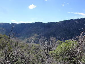
Catalina's Backside by BrettVet  The northern half of the Catalina mountain range is affectingly called "The Backside" by locals, not in relation to any particular body part, just in reference to being away from Tucson. Very few people hike the backside trails because most are steep and rocky. The Crystal Spring Trail is neither and can be accessed from an intersection of the Butterfly Trail about 1 mile in from the Soldiers Camp trailhead or the Control road. Most people think the control road is named for a fire control road, but it is actually named that because before the Mt Lemmon Highway was built, it was the only access to Summerhaven. It was so narrow that the timber wagons and cars could not pass each other, so they "controlled" the direction up in the morning and down in the afternoon. The Control Road takes off the Mt. Lemmon Highway at the fire station (mile 24.5) and turns to dirt just past the fire station. Road conditions on the Control road can be variable and seasonal. Most of the time, a high clearance 2 wheel drive vehicle has no problem if you are careful. The trailhead is on the right, 2.8 miles from the fire station, about a hundred yards after the metal gate. It s not well marked with only a metal post. Park in a campsite on the opposite side of the road. I would skip this road if it looks like snowfall is imminent. The northern half of the Catalina mountain range is affectingly called "The Backside" by locals, not in relation to any particular body part, just in reference to being away from Tucson. Very few people hike the backside trails because most are steep and rocky. The Crystal Spring Trail is neither and can be accessed from an intersection of the Butterfly Trail about 1 mile in from the Soldiers Camp trailhead or the Control road. Most people think the control road is named for a fire control road, but it is actually named that because before the Mt Lemmon Highway was built, it was the only access to Summerhaven. It was so narrow that the timber wagons and cars could not pass each other, so they "controlled" the direction up in the morning and down in the afternoon. The Control Road takes off the Mt. Lemmon Highway at the fire station (mile 24.5) and turns to dirt just past the fire station. Road conditions on the Control road can be variable and seasonal. Most of the time, a high clearance 2 wheel drive vehicle has no problem if you are careful. The trailhead is on the right, 2.8 miles from the fire station, about a hundred yards after the metal gate. It s not well marked with only a metal post. Park in a campsite on the opposite side of the road. I would skip this road if it looks like snowfall is imminent.The first 2 miles from the Control road, the trail is well-maintained and reasonable level, and it parallels the mountainside winding in and out of streams. Lots of scrub oak and clear running streams with seasonal waterfalls. Wildlife is definitely more abundant on the backside because of the privacy: Bear, deer, and the occasional mountain lion like this area. Crystal Spring is anticlimactic compared to the creek beds you had to cross getting to it. It is about a mile and a half in. From the spring, the trail deteriorates fairly rapidly as it goes through the Bullock Fire area. It is overgrown with brush, the razor kind with lots of poison ivy because of the abundant water. It climbs steadily for about 2 miles to the butterfly trail. At this intersection, the right will take you to the soldier camp trailhead, and the left will take you around the backside of Mount Bigelow and add 4 to five miles to the hike. This would be a great 2 car shuttle hike to either trailhead or hike as far as you can and do an out and back hike. The first mile or two from the control road is a great hike for kids because it is easy, has great views with water to play in, and is an adventure getting there. I hike this trail to the spring and back frequently and have never seen another hiker. Gate Policy: If a gate is closed upon arrival, leave it closed after you go through. If it is open, leave it open. Leaving a closed gate open may put cattle in danger. Closing an open gate may cut them off from water. Please be respectful, leave gates as found. The exception is signage on the gate directing you otherwise. Check out the Official Route and Triplogs. Leave No Trace and +Add a Triplog after your hike to support this local community. One-Way Notice This hike is listed as One-Way. When hiking several trails on a single "hike", log it with a generic name that describes the hike. Then link the trails traveled, check out the example. | ||||||||||||||||||||||||||||||||||||||||||||||||||||||||||||||||||||||||||||||||||||||||||||||||||||||||||||||||||||||||||||||||||||||||||||||||||||||||||||||||||||||||||||||||||||||||||||||||||


