Passage 3 continues north through the Canelo Hills. This section features rolling grasslands, chaparral, and a rich riparian environment. The trail follows a singletrack path that winds up several short, steep hills and through dry wash crossings. Since the area has abundant livestock grazing you’ll see numerous cows and encounter frequent gates.
This section begins with a moderate climb from the Canelo Pass Trailhead up to a saddle with scenic views of rolling hills, shallow canyons and lush grasslands. From here, one is offered panoramic views of the Santa Rita Mountains to the northwest and the Patagonia Mountains to the southwest.
The trail drops into the upper end of Meadow Valley and then continues through rolling hills lined with oak and manzanita. Hundreds of plant and animal species thrive in the nearby Patagonia-Sonoita Creek Preserve which makes it possible to catch a glimpse of a rare, violet-crowned hummingbird, a northern beardless-tyrannulet, or a gray hawk!
Gate Policy: If a gate is closed upon arrival, leave it closed after you go through. If it is open, leave it open. Leaving a closed gate open may put cattle in danger. Closing an open gate may cut them off from water. Please be respectful, leave gates as found. The exception is signage on the gate directing you otherwise.
When hiking several trails on a single "hike", log it with a generic name that describes the hike. Then link the trails traveled, check out the example.
WARNING! Hiking and outdoor related sports can be dangerous. Be responsible and prepare for the trip. Study the area you are entering and plan accordingly. Dress for the current and unexpected weather changes. Take plenty of water. Never go alone. Make an itinerary with your plan(s), route(s), destination(s) and expected return time. Give your itinerary to trusted family and/or friends.
Permit $$
None
Coronado Forest MVUMs are rarely necessary to review unless mentioned in the description or directions Coronado Motor Vehicle Use Maps (MVUMs)
Directions
Road
Paved - Car Okay
To hike South
This passage does not feel as isolated as the previous two, but it is seldom used. From the town of Patagonia, follow Harshaw Road (FR 58) east 14 miles to an intersection where FR 58 makes a 90-degree turn to the right. Avoid this turn and continue straight ahead (east) on FR 799. In 5 miles, cross Canelo Pass and continue about 0.5 miles down the other side to a large parking area on the left (west) side of the road. The trail toward Patagonia departs from the right side of a kiosk; the trail arriving from Passage 2 is on the left side of the kiosk.
From the town of Sonoita, follow AZ 83 south for 18 miles to a turnoff on the right for FR 799. Continue 2.9 miles to a parking area on the right that is marked with Arizona Trail signs.
Please note there is no public access to the AZT along Red Rock Canyon Road due to private property and a locked gate.
North
From the north, follow Highway 82 toward the town of Patagonia. Four miles north of town, turn right/west on Casa Blanca Canyon Road. Follow this dirt road west for 1/4-mile and look for the trailhead on your left/south. Park here, walk through the AZT gate, and follow the Connector Trail for 1/3-mile to locate the Arizona Trail. There is no parking or access along Highway 82; instead please use the Casa Blanca Canyon Trailhead nearby.
 Route Editor

 Passage 3 continues north through the Canelo Hills. This section features rolling grasslands, chaparral, and a rich riparian environment. The trail follows a singletrack path that winds up several short, steep hills and through dry wash crossings. Since the area has abundant livestock grazing you’ll see numerous cows and encounter frequent gates.
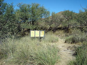


