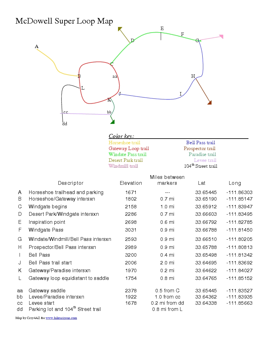
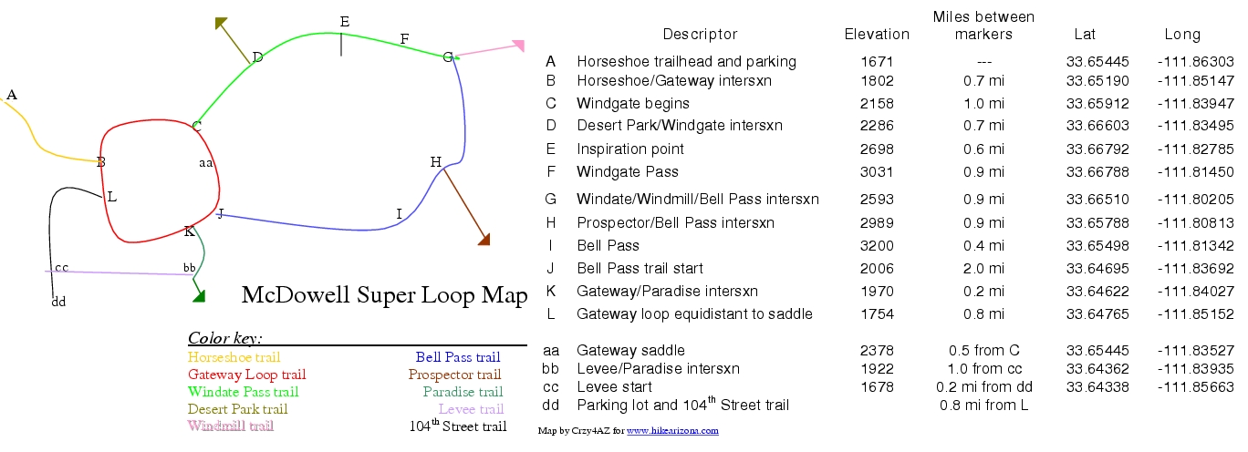
The newest (2007) City of Scottsdale trails in the McDowell Sonoran Preserve forms a super loop with many points of entry and options to extend your distance or accumulated elevation gain. This description is from the largest available parking area in a clockwise direction to Windgate Pass then to Bell Pass and around Gateway Loop back to the parking area.
Starting from Horseshoe Trail (point A on the Super Loop map), there is minimal elevation change to connect with Gateway Loop trail (point B). Take a left and follow Gateway until it intersects with one end of Windgate Pass Trail (point C). You could go to the top of Gateway Saddle and back or make the saddle (point aa) part of your return loop.
It is a steady climb to Windgate Pass (3031 ft) over the next 2.2 miles. Tom's Thumb is visible to the left and McDowell Peak looms above on the right. On this section, the Desert Park trail (point D) merges with Windgate Pass Trail, and further up is an option to go 100 feet to Inspiration Point (point E).
From Windgate Pass (point F), continue down and around to the trail's end as it intersects with Bell Pass trail and Windmill Trail (point G). This area is completely away from any housing developments or construction, and Thompson Peak is in view around the turn, in the loop. Continue up to Bell Pass (point I) arriving at the highest point on the loop.
Descend Bell Pass Trail and you can complete the loop over Gateway Saddle and throw on more (372 ft) elevation gain or continue around Gateway Loop returning to Horseshoe trail.
Of course, the loop can be approached counter-clockwise by parking at the Bell/104th Street lot and heading out on Levee trail or 104th Street trail (point cc and dd), but this parking can only hold about 12-16 cars and is not slated to expand.
Other loop extenders for more distance and accumulated elevation gain:
1. Desert Park trail (point D): Shares a trailhead with Horseshoe trail. It's 2.7 miles to the intersection with Windgate Pass Trail.
2. Windmill trail (point G): Connects with McDowell Mountain Regional Park trail system.
3. Prospector trail (point H): Connects with the road to Thompson Peak and McDowell Mountain Regional Park trail system.
4. Paradise Trail (point K): Connects to Quartz trail which connects to Lost Dog Wash trail which connects to Sunrise trail. That would be a whopper of a hike.
WARNING! Hiking and outdoor related sports can be dangerous. Be responsible and prepare for the trip. Study the area you are entering and plan accordingly. Dress for the current and unexpected weather changes. Take plenty of water. Never go alone. Make an itinerary with your plan(s), route(s), destination(s) and expected return time. Give your itinerary to trusted family and/or friends.
Permit $$
None
Directions
Road
Paved - Car Okay
To Horseshoe Trailhead Take the 101 Pima Freeway to the Princess Drive/Pima Road exit. Go north on Pima Road to Union Hills Drive. Turn right (east) on Union Hills Drive. Turn into the parking lot for the health club at the southeast corner of Union Hills Drive and North Thompson Peak Parkway. Parking for the Horseshoe Trail is permitted in the southeast corner of the lot. A sign for the McDowell Sonoran Preserve marks the start of the trail.
From PHX (I-10 & AZ-51) - 28.9 mi, 34 mins From TUC (Jct 1-10 & Grant) - 126 mi, 2 hours 5 mins From FLG (Jct I-17 & I-40) - 140 mi, 2 hours 31 mins
 Route Editor

 The newest (2007) City of Scottsdale trails in the McDowell Sonoran Preserve forms a super loop with many points of entry and options to extend your distance or accumulated elevation gain. This description is from the largest available parking area in a clockwise direction to Windgate Pass then to Bell Pass and around Gateway Loop back to the parking area.
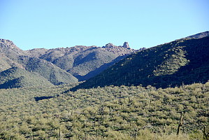


