 Route Editor

| Guide | ♦ | 51 Triplogs | 0 Topics |
details | drive | permit | forecast | 🔥 route |
stats |
photos | triplogs | topics | location |
| 158 | 51 | 0 |
Ponder the Sixth 'C' That Never Was by tdwood  Overview This easygoing, rambling route among the saguaro and sage functions as an efficient, direct connection between the western leg of the Go John Trail and the park’s campground. Overview This easygoing, rambling route among the saguaro and sage functions as an efficient, direct connection between the western leg of the Go John Trail and the park’s campground.History Cave Creek Regional Park was incorporated into the Maricopa County regional park system in 1963.
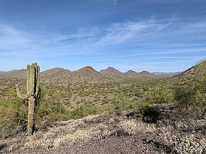
Hike Beginning from a point ~0.2 miles north along the Go John Trail (from the kiosk), the route proceeds west along the southern flank of an unnamed peak affording clear panoramic views to the south and west across the expansive Phoenix Sonoran Preserve. Though portions of the viewshed are compromised by varying degrees of development, it’s easy to look past with so much open space. At 0.7 miles, the route meets up with the Overton Trail. A left turn here will return you to the Nature Center and parking areas to the south. For those wishing to explore deeper into the interior, a right turn at the junction carries you north for 1.5 miles to a terminus farther along the Go John Trail, providing options for shorter or longer return loops as well as access to points west and north along the 315-mile loop known as the Maricopa Trail. Continuing west from the Overton junction, the trail soon begins its descent towards the campground 0.7 miles ahead, passing north of the horseback trail ride concession. Once past the concession, be on the lookout to your left for a bench placed in the memory of Marc Buckhout. Just past the bench, a side trail brings you to the hidden gated entry of the Clay Mine, so named because…well…that’s what it is — a site where clay was mined. The material was in big demand for construction in the days before and during World War II. With no other profitable industrial applications beyond that, an extractive economy never developed around clay the way it did with copper or gold. At one time, there were ranger-led excursions into the mine. As of this writing, the excursion no longer appears on the park website’s calendar of events. Further west along the route a concrete slab is all that remains of a forgotten structure. How remote it must have been when once it stood. From here the route continues to descend, soon terminating at the campground. Water Sources Water available at the nature center. Camping Available in the campground (fee extra) at the western terminus of the trail BY RESERVATION ONLY. Gate Policy: If a gate is closed upon arrival, leave it closed after you go through. If it is open, leave it open. Leaving a closed gate open may put cattle in danger. Closing an open gate may cut them off from water. Please be respectful, leave gates as found. The exception is signage on the gate directing you otherwise.
Check out the Official Route and Triplogs. Leave No Trace and +Add a Triplog after your hike to support this local community. One-Way Notice This hike is listed as One-Way. When hiking several trails on a single "hike", log it with a generic name that describes the hike. Then link the trails traveled, check out the example. | ||||||||||||||||||||||||||||||||||||||||||||||||||||||||||||||||||||||||||||||||||||||||||||||||||||||||||||||||||||||||||||||||||||||||||||||||||||||||||||||||||||||||||||||||||||||||||||


