Route Editor

| Guide | ♦ | 6 Triplogs | 0 Topics |
details | drive | no permit | forecast | route |
stats |
photos | triplogs | topics | location |
| 54 | 6 | 0 |
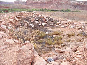
A ruined Chacoan outlier. by PaleoRob  Situated on a low gravel bluff overlooking the town of Bluff. In the late 1000's, this valley would have been filled with small hamlets and fields, irrigated by water from the San Juan River. The Bluff Great House, standing several stories tall with a ceremonial Great Kiva and Chacoan road, would have been the center of society along this stretch of the river. Now the village is a large pile of rubble, the kiva a sunken circular area, and the road just an eroded swath. While some excavation and pot hunting has gone on at the ruin over the years, it has not been rebuilt like nearby Edge of the Cedars. Potsherds and other artifacts litter the ground around the ruin; please leave them where they lay.
Heading to the right, the trail rises up a portion of the ruin. Several remains of walls can be seen poking through the rubble, and a few sunken area denote rooms or interior kivas. The trail then winds down to the base again and circles to the north side of the ruin. Here you can see remains of the encircling wall, and on the backside a small section of excavated room. Here you can see a great example of outlier Chacoan masonry. It is not as finely finished as "core" Chacoan structures, but the classic core-and-veneer construction is present here. From this point, the trail winds around the back of the structure and meets back up with the other branches at the main junction. Follow the western branch to see the remains of the Great Kiva, and then head back to your vehicle by the same path as you came. The paved road that you cross to and from the vehicle to the ruin is the Cemetery Road, which leads to the Bluff Cemetery. Pioneers, and their descendants, are buried here on the mesa top. One has to wonder how many ancient artifacts and burials the undertakers of Bluff have encountered. Check out the Official Route and Triplogs. Leave No Trace and +Add a Triplog after your hike to support this local community. | ||||||||||||||||||||||||||||||||||||||||||||||||||||||||||||||||||||||||||||||||||||||||