 Route Editor

| Guide | ♦ | 25 Triplogs | 1 Topic |
details | drive | permit | forecast | 🔥 route |
stats |
photos | triplogs | topic | location |
| 212 | 25 | 1 |
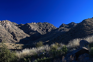
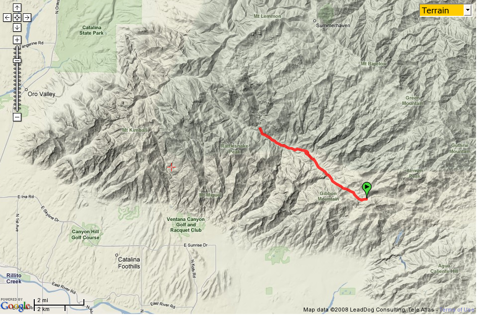
East Fork, West Fork, which is the Best Fork? by fricknaley   AKA: The Hard Way AKA: The Hard WayI've wanted to go out to Hutch's Pool again for years, and lately, I have realized that a long trip out of the Hirabiyashi Campground via the Sycamore Reservoir, East Fork, and West Fork Trails might be a sweet way to go. I was wrong. It is THE way to go! This route has it all: water, falls, saddles, canyons, and some of the most outstanding views I have laid eyes on in the Catalinas, or anywhere in southern Arizona, for that matter. This is a long, rather grueling hike with multiple ups and downs. From the pullout at the Hirabiyashi Campground's end, take off on the Sycamore Reservoir Trail #39. I have described this trail as it's own separate hike, so you can check that out if you like. This trail takes off and passes through the old Prison Camp site, with the foundations the only visible remnants of the old structures. It follows an old, wide 4x4 road that will flow with water if there has been recent rain. It goes level then climbs briskly after a total of 0.8-miles to the magnificent Shreve Saddle and the official trailhead of the Arizona Trail segment of the Sycamore Reservoir Trail. There are enormous views out over Sabino Basin from here.
Go back to the sign and go right. A couple of large cairns point the way to where the trail deposits you and crosses the wide sandy floor of Bear Canyon. Cairns also mark where it climbs out the other side. Be careful if there is water running here, which there often is. Today there was a lot. As you climb out the other side and continue along, the trail parallels the creek flowing down from Sycamore Canyon, which is roaring at times. There are intermittent areas of burn again, with bright green regrowth too. Within about 0.25-miles of the crossing, a cairned route breaks off to the right. This leads to some unmarked campsites, so stay straight. About 0.5-miles from the crossing, a cairned trail breaks off to the left. Then leads to the Bear Canyon trail. Again, stay straight. You will make another creek crossing, which can be tricky if there is severe water running, then come to a signed intersection. This is the junction of Bear Canyon Trail to the left, and East Fork Trail 24A straight ahead. Sycamore Reservoir trail ends here. This intersection is about 1-mile from the Bear Canyon creek crossing, 0.5-miles from the cairned shortcut to Bear Canyon Trail, and roughly 3.25-miles from your car. Take to East Fork Trail down the saddle and strap your jaw on as thunderous views of Sabino Canyon and Basin explode out and down from where you stand. Far below and to the right, the East Fork Creek roars along its green-tree lined way, fed by Palisade and Box Camp Canyons. The trail soon descends/switchbacks sharply down to the floor, losing several hundreds of feet (climb on the way out). There are short sectors of significant exposure here, so watch your footing. This is among the best scenery I've seen here. After nearly 0.75-miles from the intersection, you are on the southern floor of the East Fork trail and running along the creek. A sign for Palisade trail is noted, follow the East Fork trail. There are more waterfalls than you could count here. Follow the East fork trail for about another mile to the next signed intersection with the Box Camp Trail. Stay along the East Fork 24A until a signed junction dead ends you at the creek. The sign is on the ground right beneath a large tree branch. To your left is Sabino Canyon 23, which leads to the paved tram line road in 2.6-miles. The West Fork Trail #24 is your destination. Immediately the West Fork makes a creek crossing, which is marked by cairns. Today the creek was flowing strongly, and there are multiple cascades and small falls here, making this the highlight of the hike. Just stunning. Anyway, carefully cross the creek then climb up a little to skirt along the north bank of West Fork Creek. As you swing around on this trail, there are occasional giant saguaros and intermittent views down Sabino Canyon that provide Sabino Canyon's most outstanding aspects that I have ever seen. I kept stopping to say "Wow" to myself. After about 1.5-miles on this sweet trail, the path crosses over the creek. This is the most challenging crossing if there is water going. Shortly after that, you reach the turnoff for Hutch's Pool. There is no sign here, but numerous side trails are heading off to the right to take you to the pool. Hutch's Pool is a long and narrow permanent pool in a sheer rock gorge and a well known local landmark. Return the way you came and prepare for the bulk of the climbing is on the way back. As a note, pay attention after crossing the creek to the junction with Sabino Canyon trail and East Fork. The small sign is easy to miss, and you can end up on the Sabino Canyon trail going the wrong way. I met someone out there who had done just this and was scrambling to make up time.
Check out the Official Route and Triplogs. Note This is a moderately difficult hike. Leave No Trace and +Add a Triplog after your hike to support this local community. | |||||||||||||||||||||||||||||||||||||||||||||||||||||||||||||||||||||||||||||||||||||||||||||||||||||||||||||||||||||||||||||||||||||||||||||||||||||||||||||||||||||||||||||||||||||||||||||||||||||||||||||||||||


