 Route Editor

| Guide | ♦ | 91 Triplogs | 2 Topics |
details | drive | permit | forecast | 🔥 route |
stats |
photos | triplogs | topics | location |
| 796 | 91 | 2 |
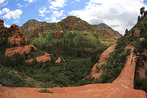
Popular Arch by joebartels   History HistoryTraveling from Winslow, Mr. and Mrs. Vultee experienced engine trouble in a snow storm. The nearby arch was named in their honor. A plaque has been placed on a nearby sandstone ledge in their memory. Alternative Twice as steep, yet an easier sedan access option is to use Sterling Pass Trail #46. Mileage is almost identical.
This trail receives a fair amount of traffic simply for the sake of viewing the arch. The arch is interesting. Personally, I go for the trail. From the trailhead, you will follow a rut. Actually, you need to follow the rut a bit to get to the officially signed trailhead. The trail follows the Sterling Canyon creek bed. Crossing the creek several times along the way. I enjoy this area due to the tree coverage, making this an ideal summer hike, in my opinion—ideal being near 85 degrees or less. The creek is dry except for runoff, so technically, I guess it's a wash. Mixed vegetation makes up the area. Dry Creek to the west offers a more Sedona feel with the large sandstone slabs. Here the forest is dense. Making it more reminiscent of creeks in the southeastern states with a touch of Sedona, in my opinion. The trail is easy to follow. Little elevation is gained. Several creek crossings do keep you going up and down a few times within the hike. Upon reaching the junction with Sterling Pass, veer left. There is a short segment of the trail over to the lookout on a sandstone ledge. Having done this trail numerous times, it seems like I never get the same trail over to the ledge. There's nothing to worry about, the area is just heavily used, and trails seem to go everywhere. Others say I'm nuts, and the trail is obvious. At any rate, be careful walking around the ledge as the sides are steep. You can bushwhack over to the arch. From what I'm told, there is a trail somewhere. I've never gone over myself. This is the easy approach to Vultee Arch. You can take the Sterling Pass trail off 89A for a more strenuous 4.8-mile roundtrip hike. For an avid hiker like myself, check this out. Park at Vultee. Hike up, over, and down Sterling Pass. Then head up the road to Slide Rock. Play in the water and head back. If you've ever been to Sedona on a perfect day, you know getting a parking space at Slide Rock is out of the question. Around an eleven-mile excursion, this is an all-day adventure, but I enjoy it! I did a mountain bike shuttle for the highway section. No personal photos up yet. Summer of '99, I shot the area. On a second hike that day in West Fork, I dropped the film in Oak Creek. Okay, I slipped and looked like the biggest fool around. The next day I decided to give up 35mm and got a 2.5MP digital. Digitals being quick, easy, and painless; I'm glad it happened. Camping According to the 2018 FS map camping is allowed outside the green line. Which looks to be after a mile into the hike.
Coconino FS Details A short, easy hike along the bottom of Sterling Canyon. The drainage is dry most of the year. Shade is available, but it would be wise to carry some water in the warm months. The trail deadends at a bronze plaque place in memorium for Gerard and Sylvia Vultee who lost their lives in an aircraft crash on January 29, 1938. The actual crash site is more than a mile north and at a much higher elevation, on East Picket Mesa. On the north side of the canyon across from the plaque is the sandstone arch named for Vultee, an early aircraft designer from California. Just before the plaque site there is a junction with the Sterling Pass Trail which continues over into Oak Creek Canyon. Check out the Official Route and Triplogs. Leave No Trace and +Add a Triplog after your hike to support this local community. | ||||||||||||||||||||||||||||||||||||||||||||||||||||||||||||||||||||||||||||||||||||||||||||||||||||||||||||||||||||||||||||||||||||||||||||||||||||||||||||||||||||||||||||||||||||||||||||||||||||||||||||||||||||||||||||||||


