This is a very pleasant, rather short loop through an area of bubbling springs, green grasses, big trees, and long-distance views. It is located conveniently close to Bog Springs Campground and the other developed recreation sites within the Madera Canyon Recreation Area, making this a popular trail where you can usually count on having company. The two friendly paths that form this loop afford excellent opportunities for observing birds and other wild animals drawn to the oases nourished by the springs.
The Bog Springs/Kent Spring loop starts in Bog Springs Campground and wanders up and around a shallow basin these drainages have cut into the western slopes of the Santa Rita Range. Forests of Silverleaf oak, alligator juniper, and ponderosa pine shade the trail as it meanders between springs and seeps sheltered by stands of gnarled old Arizona sycamores. In addition to these silver and green barked old-timers, communities of other moisture-loving plants cluster around these reliable water sources including Arizona bamboo, Arizona walnut, alligator junipers, and colorful clumps of wildflowers. As you might suspect, such lush pockets of riparian diversity also attract a variety of birds and other wildlife.
The convenience of these trails and the wild abundance that surrounds them, make them extremely popular, so don't be surprised if you have company. Favorite trailside lunch spots and viewpoints are well worn and easy to find. Where the trees part to provide overlooks, you can expect to enjoy good views of Madera Canyon while panoramas stretch to the Baboquivari Mountains and Kitt Peak Observatory in the distance. The trail steepens in the vicinity of Kent Spring, but few people would call this a very strenuous walk or horse ride. It takes only a couple of hours to complete a full circuit, but don't be surprised if you spend all day.
When hiking several trails on a single "hike", log it with a generic name that describes the hike. Then link the trails traveled, check out the example.
WARNING! Hiking and outdoor related sports can be dangerous. Be responsible and prepare for the trip. Study the area you are entering and plan accordingly. Dress for the current and unexpected weather changes. Take plenty of water. Never go alone. Make an itinerary with your plan(s), route(s), destination(s) and expected return time. Give your itinerary to trusted family and/or friends.
Four specific day-use areas require a Coronado Recreational Pass or a National Pass/America the Beautiful Pass.
1) Sabino Canyon - located on the Santa Catalina Ranger District (520)749-8700
2) Madera Canyon - located on the Nogales Ranger District (520)281-2296
3) Cave Creek - located on the Douglas Ranger District (520)364-3468
4) Mt. Lemmon at 11 day-use sites.
2025Catalina State Park
Per vehicle (1 person): $10.00
Per vehicle (2-4 people): $20.00
Individual/bicycle: $5.00
Coronado Forest MVUMs are rarely necessary to review unless mentioned in the description or directions Coronado Motor Vehicle Use Maps (MVUMs)
Directions
Road
Paved - Car Okay
To hike From Interstate 10, take Interstate 19 to the Continental exit (just south of Green Valley). Go left (southeast) for approximately 13 miles, you can follow the signs for Madera Canyon. You will see signs for Bog Springs Campground. Follow the road to the campground about .5 miles. There is a SMALL day parking area at the top of the campground. The trailhead is signed and is near campsite 13. Additional information on trails in the area is available from Santa Rita Lodge 520-625-8746.
 Route Editor


 This is a very pleasant, rather short loop through an area of bubbling springs, green grasses, big trees, and long-distance views. It is located conveniently close to Bog Springs Campground and the other developed recreation sites within the Madera Canyon Recreation Area, making this a popular trail where you can usually count on having company. The two friendly paths that form this loop afford excellent opportunities for observing birds and other wild animals drawn to the oases nourished by the springs.
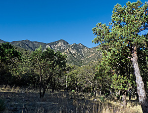


