This trail provides access to the upper slopes of Mt. Hopkins, the second most prominent peak in the Santa Ritas. The trail leaves from Roundup Picnic Area at the end of Madera Canyon Road. It earned its descriptive name because it climbs 1,400 feet in a distance of a little over one-half mile. This heart-thumping climb leads from upper Madera Canyon to the vicinity of Agua Caliente Saddle, where that trail branches off toward Josephine Saddle and several other trails that crisscross the upper slopes of the Santa Rita Mountains.
If you arrange a shuttle in advance, a trip that stretches between this trailhead and the Very Steep/Vault Mine trailhead in Madera Canyon makes a good long day hike. A loop that doesn't require a shuttle takes you up the Very Steep/Vault Mine trail to Agua Caliente Saddle, then northeast to Josephine Saddle, and back to the Roundup parking Area via the Lower end of either Old Baldy or Super Trail.
1.5 miles of the Very Steep/Vault Mine Trail are within the Mt. Wrightson Wilderness. Mechanized vehicles, including mountain bikes, are not permitted in Wilderness areas.
When hiking several trails on a single "hike", log it with a generic name that describes the hike. Then link the trails traveled, check out the example.
WARNING! Hiking and outdoor related sports can be dangerous. Be responsible and prepare for the trip. Study the area you are entering and plan accordingly. Dress for the current and unexpected weather changes. Take plenty of water. Never go alone. Make an itinerary with your plan(s), route(s), destination(s) and expected return time. Give your itinerary to trusted family and/or friends.
Four specific day-use areas require a Coronado Recreational Pass or a National Pass/America the Beautiful Pass.
1) Sabino Canyon - located on the Santa Catalina Ranger District (520)749-8700
2) Madera Canyon - located on the Nogales Ranger District (520)281-2296
3) Cave Creek - located on the Douglas Ranger District (520)364-3468
4) Mt. Lemmon at 11 day-use sites.
2025Catalina State Park
Per vehicle (1 person): $10.00
Per vehicle (2-4 people): $20.00
Individual/bicycle: $5.00
Coronado Forest MVUMs are rarely necessary to review unless mentioned in the description or directions Coronado Motor Vehicle Use Maps (MVUMs)
Directions
Road
Paved - Car Okay
To Madera Canyon Trailhead From Tucson: I-19 south to exit 63 Continental. At the end of the exit take a left and follow brown signs to Madera Canyon. You'll be taking White House Canyon Road 13.2 miles to Madera Canyon.
From PHX (I-10 & AZ-51) 152 mi - about 2 hours 31 mins From TUC (Jct 1-10 & Grant) 42.3 mi - about 55 mins From FLG (Jct I-17 & I-40) 295 mi - about 4 hours 37 mins
 Route Editor


 This trail provides access to the upper slopes of Mt. Hopkins, the second most prominent peak in the Santa Ritas. The trail leaves from Roundup Picnic Area at the end of Madera Canyon Road. It earned its descriptive name because it climbs 1,400 feet in a distance of a little over one-half mile. This heart-thumping climb leads from upper Madera Canyon to the vicinity of Agua Caliente Saddle, where that trail branches off toward Josephine Saddle and several other trails that crisscross the upper slopes of the Santa Rita Mountains.
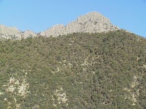


