This trail leads to the 9,453-foot summit of Mt. Wrightson, the highest peak in the Santa Ritas. The Super Trail is long but has a moderate gradient. When combined with Old Baldy Trail, it forms a figure eight, making it possible to put together several different loops, using other portions for ascent or descent.
The Super Trail stays within the same drainage as its steeper cousin in the lower loop of the "8", Old Baldy, but follows a more south-facing slope through a high desert environment in the upper loop. Above the midpoint of the "8", at Josephine Saddle, the Super Trail loops around the south side of the mountain through even more arid country, while Old Baldy switchbacks through thickets of New Mexico locust on a west-facing slope at Baldy Saddle. The last mile to the summit of Mt. Wrightson via the Crest Trail is the same no matter which trail you've followed to the saddle.
The views from the summit are breathtaking. The Santa Catalinas near Tucson, Mt. Graham to the east, and the high peaks of the Huachucas to the southeast combine with sweeping views of the Santa Cruz and San Pedro valleys to form a 360' panorama. You don't even have to go all the way to the top to enjoy great views. Many of these landmarks are visible from dozens of overlooks along both trails. And while you're at it, remember that all that's worth seeing here is not in the distance. The bird watching' heaven that exists in Madera Canyon extends up the mountain into this area where, in addition to the birds, you may see Coues white-tailed deer, black bear, and even mountain lion if you're fortunate. The Old Baldy trail also boasts an impressive potpourri of tree species characteristics of southeastern Arizona, including Arizona, Apache, and Chihuahua pines, as well as Arizona madrone and various oaks.
Except for the lower half-mile, the Super Trail is within the Mt. Wrightson Wilderness. Mechanized vehicles, including mountain bikes, are not permitted in Wilderness areas.
When hiking several trails on a single "hike", log it with a generic name that describes the hike. Then link the trails traveled, check out the example.
WARNING! Hiking and outdoor related sports can be dangerous. Be responsible and prepare for the trip. Study the area you are entering and plan accordingly. Dress for the current and unexpected weather changes. Take plenty of water. Never go alone. Make an itinerary with your plan(s), route(s), destination(s) and expected return time. Give your itinerary to trusted family and/or friends.
Four specific day-use areas require a Coronado Recreational Pass or a National Pass/America the Beautiful Pass.
1) Sabino Canyon - located on the Santa Catalina Ranger District (520)749-8700
2) Madera Canyon - located on the Nogales Ranger District (520)281-2296
3) Cave Creek - located on the Douglas Ranger District (520)364-3468
4) Mt. Lemmon at 11 day-use sites.
2025Catalina State Park
Per vehicle (1 person): $10.00
Per vehicle (2-4 people): $20.00
Individual/bicycle: $5.00
Coronado Forest MVUMs are rarely necessary to review unless mentioned in the description or directions Coronado Motor Vehicle Use Maps (MVUMs)
Directions
Road
Paved - Car Okay
To Madera Canyon Trailhead From Tucson: I-19 south to exit 63 Continental. At the end of the exit take a left and follow brown signs to Madera Canyon. You'll be taking White House Canyon Road 13.2 miles to Madera Canyon.
From PHX (I-10 & AZ-51) 152 mi - about 2 hours 31 mins From TUC (Jct 1-10 & Grant) 42.3 mi - about 55 mins From FLG (Jct I-17 & I-40) 295 mi - about 4 hours 37 mins
 Route Editor


 This trail leads to the 9,453-foot summit of Mt. Wrightson, the highest peak in the Santa Ritas. The Super Trail is long but has a moderate gradient. When combined with Old Baldy Trail, it forms a figure eight, making it possible to put together several different loops, using other portions for ascent or descent.
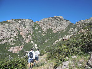


