 Route Editor

| Guide | ♦ | 20 Triplogs | 0 Topics |
details | drive | permit | forecast | 🔥 route |
stats |
photos | triplogs | topics | location |
| 132 | 20 | 0 |
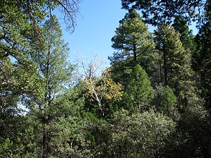
  The Greaterville Trail #79, combined with the East Sawmill Canyon Trail, provides access from the northeast to Florida Saddle, one of the major trail crossroads in the Santa Rita Range. This saddle marks the beginning of the Crest Trail #144 that leads to the summit of Mt. Wrightson. The Greaterville and East Sawmill Canyon Trails pass through an area of rugged, scrub oak-clad ridges and forested canyons that slope gradually toward the Santa Rita Mountains. Both offer views to the east of the Whetstone Mountains and Mustang Mountains, as well as to the west of Mt. Wrightson and the Santa Rita crest. Closer at hand, Ponderosa Pine, Alligator Juniper, and Emory Oak, Arizona White Oak, and Silverleaf Oak make up most of the scenery. The Greaterville Trail #79, combined with the East Sawmill Canyon Trail, provides access from the northeast to Florida Saddle, one of the major trail crossroads in the Santa Rita Range. This saddle marks the beginning of the Crest Trail #144 that leads to the summit of Mt. Wrightson. The Greaterville and East Sawmill Canyon Trails pass through an area of rugged, scrub oak-clad ridges and forested canyons that slope gradually toward the Santa Rita Mountains. Both offer views to the east of the Whetstone Mountains and Mustang Mountains, as well as to the west of Mt. Wrightson and the Santa Rita crest. Closer at hand, Ponderosa Pine, Alligator Juniper, and Emory Oak, Arizona White Oak, and Silverleaf Oak make up most of the scenery.This area has a good wildlife habitat. There are healthy populations of Coues white-tailed deer in the area and, if your eye is sharp enough to see them before they flush, you might spot some scaled quail or Montezuma quail. From the western terminus of East Sawmill Canyon Trail, you can head north into Florida Canyon, south and east along Cave Creek Canyon, or continue along the Crest Trail to the top of the Santa Ritas.
Check out the Official Route and Triplogs. Leave No Trace and +Add a Triplog after your hike to support this local community. One-Way Notice This hike is listed as One-Way. When hiking several trails on a single "hike", log it with a generic name that describes the hike. Then link the trails traveled, check out the example. | ||||||||||||||||||||||||||||||||||||||||||||||||||||||||||||||||||||||||||||||||||||||||||||||||||||||||||||||||||||||||||||||||||||||||||||||||||||||||||||||||||||||||||||||||||||||||||||||||||||||||||


