Background
The Box Spring Trail #22A was likely blazed by early Tucson pioneer families that once spent their summers in the Soldier Camp area of Mount Lemmon near Summerhaven. The accompanying Box Camp trail (#22) was once the most direct route into the Camp from Tucson before Catalina Highway was completed. As these families moved their entire households into the hills for the summer, they moved by mule train and took a route that afforded visits to steady sources of freshwater. Although Box Camp trail is still quite popular, this small spur trail sees minimal usage as its state of disrepair bears testimony.
The Hike
Reach the Box Spring Trail #22A by hiking the first 1.8 miles of the Box Canyon Trail #22. AT the junction, turn right (west) and begin downhill. The track is well-defined in some areas and overgrown with brush in others. The trail begins a slight descent into the pines and approaches a small saddle. This saddle connects to the ridge that separates Box Camp canyon from Sabino canyon. A short route leaves to the west from this saddle and terminates at a series of rocky outcroppings offering incredible vistas of upper Sabino canyon and the North Ranges.
After the saddle, the trail begins to descend steeply. The track becomes soft ground and frequently takes the form of a precipitous ledge buried in the understory. If there have been recent rains, the track will give under the footing, and caution should be exercised. After passing a short series of boulders, the trail descends into ever-thicker scrub and brush before passing by a minor drainage marked by cairns. Two tracks depart here. The trail follows the track heading due south toward Box Spring, which appears to be the source of a minor drainage visible directly to the south. This drainage is a tributary to Sabino Canyon, which is directly below and visible through the trees. You have traveled just about four-tenths of a mile, and this is presently the end of the trail. Box Spring is just above after a short climb in the drainage. The trail dissipates in the lower walls of the drainage. As of September 2008, the most likely track that once led to the final one-half mile of the trail into Sabino Canyon is now obscured by brush and blocked by a large wall of fallen trees. When these obstacles are bypassed, the canyon wall of Sabino is reached, though no obvious course is available for descent as the wall is now sheer. It is possible that whatever track once existed for the descent into the canyon was obliterated along with much of lower Sabino canyon in the floods there recently. Return the way you arrived.
WARNING! Hiking and outdoor related sports can be dangerous. Be responsible and prepare for the trip. Study the area you are entering and plan accordingly. Dress for the current and unexpected weather changes. Take plenty of water. Never go alone. Make an itinerary with your plan(s), route(s), destination(s) and expected return time. Give your itinerary to trusted family and/or friends.
Four specific day-use areas require a Coronado Recreational Pass or a National Pass/America the Beautiful Pass.
1) Sabino Canyon - located on the Santa Catalina Ranger District (520)749-8700
2) Madera Canyon - located on the Nogales Ranger District (520)281-2296
3) Cave Creek - located on the Douglas Ranger District (520)364-3468
4) Mt. Lemmon at 11 day-use sites.
2025Catalina State Park
Per vehicle (1 person): $10.00
Per vehicle (2-4 people): $20.00
Individual/bicycle: $5.00
Coronado Forest MVUMs are rarely necessary to review unless mentioned in the description or directions Coronado Motor Vehicle Use Maps (MVUMs)
Directions
Road
Paved - Car Okay
To hike Reach the Box Camp trail head by traveling roughly thirteen miles up Catalina Highway toward Summerhaven. The trail head parking area is on the south side of Catalina Highway. Take the Box Spring trail (#22) for roughly 1.8 miles to the junction with the Box Spring trail.
page created by Jeffshadows on Sep 08 2008 1:20 pm
 Route Editor

 Background
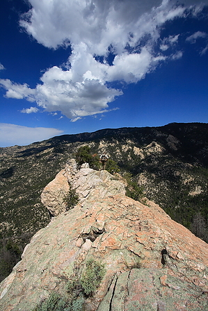


