This is a lovely, short connector of the Arizona Trail linking up the Arizona trail east of the Catalina Highway to the magnificent section taking off from Shreve Saddle as it takes you into the East and West Fork country. This little connector route is excellent for kids in packs, and the like.
The Molino Basin Trail #11 takes off from the Molino Campground and parallels the Catalina Highway to the Prison Camp at the Gordon Hirabiyashi campground. It climbs most of the way, but never severely, with a total gain of about 700 feet. There are no route-finding issues, and the trail is well-signed.
As the trail leaves the campground, the Highway is initially on the left. It then banks right and starts climbing easily into Molino Basin. As you scramble along the basin, the Catalina Highway reappears on your right and hangs out with you the rest of the way. The trail mostly parallels the drainage of the basin, crossing over it a couple of times. Occasionally it switchbacks up a little. Soon you can see where the Hirabiyashi campground breaks off from the Catalina Highway. This is where you are heading. At about 2.3 miles or so from Molino Campground, you come to a signed intersection. To the right, the trail descends to the campsites at the Hirabiyashi campground. To the left, you can continue for about 0.5 miles to the end of the gravel road in the campground at the takeoff for the Sycamore Reservoir trail.
The views along this trail are mostly out over Molino Basin and are very nice and wide open. This is a nice, easy connector segment of the Arizona Trail worth a walk if you have the time (or have a little one with you). It passes through some of the more heavily burned mid-altitude hilly grasslands of the Catalinas. The recovery is apparent most of the way.
When hiking several trails on a single "hike", log it with a generic name that describes the hike. Then link the trails traveled, check out the example.
WARNING! Hiking and outdoor related sports can be dangerous. Be responsible and prepare for the trip. Study the area you are entering and plan accordingly. Dress for the current and unexpected weather changes. Take plenty of water. Never go alone. Make an itinerary with your plan(s), route(s), destination(s) and expected return time. Give your itinerary to trusted family and/or friends.
Four specific day-use areas require a Coronado Recreational Pass or a National Pass/America the Beautiful Pass.
1) Sabino Canyon - located on the Santa Catalina Ranger District (520)749-8700
2) Madera Canyon - located on the Nogales Ranger District (520)281-2296
3) Cave Creek - located on the Douglas Ranger District (520)364-3468
4) Mt. Lemmon at 11 day-use sites.
2025Catalina State Park
Per vehicle (1 person): $10.00
Per vehicle (2-4 people): $20.00
Individual/bicycle: $5.00
Coronado Forest MVUMs are rarely necessary to review unless mentioned in the description or directions Coronado Motor Vehicle Use Maps (MVUMs)
Directions
Road
Paved - Car Okay
To Molino Basin Trailhead 1. From I-10 & Grant: Head east on W Grant Rd 8.4 mi 20 mins
2. Turn left at E Tanque Verde Rd 3.2 mi 6 mins
3. Turn left at E Catalina Hwy 6.0 mi 9 mins
In addition to the trailhead this is a large, popular campground and day use area. Parking for day use is immediately after turning into the Molino Basin. The trailhead is signed and takes off out of the day use area.
From PHX (I-10 & AZ-51) 131 mi - about 2 hours 25 mins From TUC (Jct 1-10 & Grant) 21.7 mi - about 49 mins From FLG (Jct I-17 & I-40) 275 mi - about 4 hours 31 mins
 Route Editor


 This is a lovely, short connector of the Arizona Trail linking up the Arizona trail east of the Catalina Highway to the magnificent section taking off from Shreve Saddle as it takes you into the East and West Fork country. This little connector route is excellent for kids in packs, and the like.
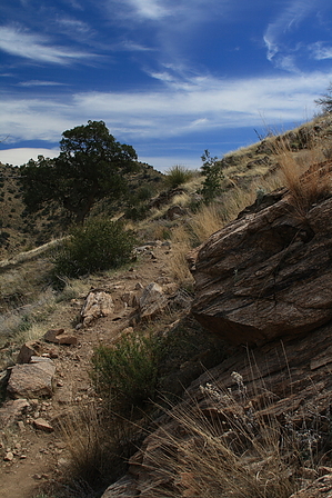


