Route Editor

| Guide | ♦ | 8 Triplogs | 0 Topics |
details | drive | permit | forecast | route |
stats |
photos | triplogs | topics | location |
| 500 | 8 | 0 |
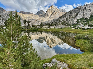
It's good to be king by chumley The Rae Lakes Loop is one of the most popular backpacking loops in Kings Canyon National Park, and for good reason. Backpackers on the loop pass through classic High Sierra scenery, ranging from lower-elevation river valleys to high mountain passes, alpine lakes, rugged peaks, and expansive views. Permit Logistics Because this is such a popular loop, the NPS manages use via a quota-based permit system during the busy summer backpacking season. Permits can be obtained on Recreation.gov beginning six months prior to your start date, beginning at 8 am Pacific Time. During the permit season, up to 25 people may begin the hike each day in each direction. Only 20 of the 25 permits are reservable in advance via Rec.gov. The remaining 5 unreserved permits are available first-come, first-served beginning at 1 pm the day before your hike begins at the Roads End permit issuing station. Permits that were reserved in advance but the permit holder does not arrive by 10 am on their start day will have their permit cancelled, and it will be released to first-come, first-served backpackers for immediate start (same day).
The loop can be hiked clockwise or counterclockwise. People have strong opinions on which is better and why. Ultimately, your permit success may dictate the direction that you go. Before deciding on your preferred direction, look at the official route and map out potential camp areas and daily distances. The high point of the loop is a few feet under 12,000 feet at Glen Pass. It is customary for daily thunderstorms to occur along the Sierra Crest in the summer months, and most hikers will want to plan their route to cross the pass earlier in the day, before riskier weather becomes more likely in the afternoon. Clockwise hikers will need to get a permit starting at Woods Creek. The first possible camping in this direction is about 7 miles from the trailhead at an elevation of 6500 feet. It's 25 miles uphill to Glen Pass, and 17 miles downhill to complete the loop. The approach to Glen Pass can be done in 2.5 miles and 1500 feet of gain from the camping area at Rae Lakes. Counterclockwise hikers will need to get a permit starting at Bubbs Creek. The first possible camping in this direction is about 4 miles from the trailhead at an elevation of 6300 feet. It's 17 miles uphill to Glen Pass, and 25 miles downhill to complete the loop. The approach to Glen Pass can be done in about 3.5 miles and 1500 feet of gain from the camp area at Charlotte Lake. Hike Description This hike is described going counter-clockwise beginning at Roads End. Both Bubbs Creek and Woods Creek trails begin at the permit station and travel the same flat, sandy, tourist-laden 2 miles through the warm valley floor at 5000 feet. In summer, this elevation can reach 100 degrees. At the 2-mile mark, clockwise hikers veer left onto the Woods Creek trail toward Mist Falls and Paradise Valley, while counterclockwise hikers stay to the right and cross Bubbs Creek at Bailey Bridge. For Bubbs Creek hikers, two additional footbridges follow shortly, with varying degrees of necessity due to current water levels. The trail begins a series of steep switchbacks, climbing 1000 feet above the valley below before moderating and reaching the first available campsite at the Sphinx junction, 4.2 miles from the start. The next 7.5 miles climb another 2000 feet along the banks of Woods Creek before reaching Junction Meadow. This stretch features a diverse sample of a typical Sierra river valley, with some shady wooded sections and other exposed and open slopes with distant views. The creek mostly follows a steady grade along a bouldery course with a few small cascades and occasional swim/plunge-possible pools. From Junction Meadow, the grade increases as the trail follows the Bubbs drainage around the southern slope of the dramatic Mt. Bago and climbs toward Lower Vidette Meadow. There's a magnificent cascade/slide down water-worn granite along this stretch, dropping several hundred feet. About 2.5 miles from Junction Meadow, the trail intersects with the PCT and JMT at Lower Vidette Meadow. Here, the route veers left and climbs unrelentingly 1200 feet in less than 2 miles to the junction for Charlotte Lake, passing the junctions for Kearsarge Pass and Lakes along the way. It's a mile off the loop to reach Charlotte Lake, but provides a good opportunity for camping prior to heading over Glen Pass. From the Charlotte Lake junction, it's 2.5 miles and 1300 feet to reach Glen Pass. After traversing above the lake, the trail passes into barren high-elevation talus along the Sierra Crest. There are two lakes in the basin approaching the pass, the first of which is easily accessible off the trail, and the second of which is not worth the effort, but looks nice! Switchbacks are cut nicely into the loose scree south of the pass. Once reaching the top, you'll be introduced to new views to the north, including down into the Rae Lakes Basin. Early season visitors may find lingering winter snow pack on the north slopes, and depending on conditions, this stretch may be impassable until later in the summer, sometimes well into July. You'll know current conditions before you begin, but not when you put in for a permit, so keep in mind the possibility that snowfall will make crossing the pass impossible, or at least more challenging if there's still snow on the trail! Assuming you have a clear trail, the descent off the north side of the pass cuts through talus and fields of granite boulders with an annoying tread made up of neatly organized baseball-sized granite cubes. Bone-jarring steps will test your knees as the route descends 2.5 miles to the Rae Lakes level at about 10,500 feet. The Rae Lakes area is the highlight of the loop, with picturesque alpine lakes surrounded by towering rugged peaks, highlighted by Fin Dome on the west slopes of Middle Rae Lake, and The Painted Lady and Dragon Peak looking back up toward the crest west of Glen Pass. Campers looking to explore more of this special environment can take side trips to Dragon Lake or to Sixty Lake Basin, each of which offers further opportunities to soak in the high Sierra scenery that surrounds Rae Lakes. Continuing the loop downstream from Rae Lakes will take you past Arrowhead Lake and Dollar Lake before the trail begins to drop steadily along a mostly exposed high-elevation valley with expansive views to the north. It's mostly pleasant hiking down to the Woods Creek Bridge about 4 miles along a moderate grade dropping 1700 feet from Dollar Lake. Shortly after the bridge at Woods Creek, a trail junction marks where the PCT/JMT departs to the northeast following Woods Creek upstream, while the loop continues downstream through Castle Domes Meadow on its way to the Upper Paradise camping area, 6 miles and downhill by 1600 feet to the west. There are some intermittent wooded sections, but much of the first half of this segment of the hike is exposed. The resulting views are the bonus, as the Castle Dome needles are a geologic highlight. About 2 miles from the Kings River crossing at Upper Paradise, the trail moves away from the river and climbs over a small ridge with excellent views of Paradise Valley. Crossing the South Fork Kings River has become more treacherous since the bridge was washed out from flooding in the winter of 2016-17. It seems that this bridge is something that NPS would like to replace, but as of 2025, there is no schedule to do so. As a result, it is mandatory to get wet to cross this river, and doing so during early-season snowmelt may be dangerous or impossible. Again, the permit ranger can explain the current conditions to you on your start date, but you won't know conditions at the time you have to secure a permit. The Upper Paradise area is immediately adjacent to the old bridge abutment and features no shortage of spots for backpackers to set up camp for the night. Heading downstream along the trail will take you through a densely forested valley within earshot of the river. About 2 miles downstream, you'll pass through a large cleared area before again entering the wooded Middle Paradise area a half mile beyond. It's a mile below Middle Paradise, where you'll pass Lower Paradise and the sign indicating that no camping is permitted between here and Sphinx Junction on the Bubbs Creek Trail, more than 6 trail miles away. From Lower Paradise, the trail makes a steady descent and leaves the shelter of a wooded canopy for some beautiful views down canyon. Impressive trail construction cuts through the slope with numerous granite steps and switchbacks that help moderate the grade as the trail drops nearly 1000 feet in the two miles between Lower Paradise and Mist Falls. Another highlight of the trip is the aptly named Mist Falls, which drops precipitously through cascades and slides before the final fall into a beautiful pool. Several viewpoints are available along the way, as well as short spur trails that lead out onto the exposed granite. Signs indicate the danger that may be present on the slick, wet rock, so take care of the risks you choose to embark upon here. It's about 2 miles more to reach the starting junction with Bubbs Creek Trail and then the retracing of your first two miles on the flat and sandy trail returning to Roads End. The Mist Falls hike is a popular out-and-back hike from Roads End, so these last 4 miles are likely to be somewhat busy with day hikers (for whom permits are not required and no quotas limit for day-use). There's potable water and pit toilets at Roads End, but it's a long drive back to civilization, so having a snack or a cooler waiting for you in the bear box in the parking lot is a good plan for your post-hike refreshment! Camping Camping is primitive along the entire route. There are no facilities. Human waste must be buried, and toilet paper must be packed out. Backpackers are required to carry an approved bear-resistant canister for all food and scented goods. There are some camping areas with a bear box, but these are not a replacement for carrying a bear canister. Popular sites along Bubbs Creek are located at Sphinx Junction (the closest to Roads End, where camping is permitted) and in the area of Junction Meadow. There are a number of other suitable sites between these two popular areas as well. Lower Vidette Meadow provides further opportunities for camping on the south side of the pass. There is no camping at Bullfrog Lake, but side trips to either Kearsarge Lakes or Charlotte Lake are possible. Camping at Charlotte Lake provides the shortest approach to Glen Pass from the south. North of Glen Pass, there are numerous camping opportunities in the Rae Lakes area, including a "primary" location along the eastern shore of Middle Rae Lake. Sites at Arrowhead and Dollar Lake provide additional opportunities. Camping in the Rae Lakes basin is limited to two nights, with only one night permitted at each lake. Downstream, there's a site near the Baxter Creek confluence 1.5 miles down from Dollar Lake, but otherwise, there's not much between the lakes and the Woods Creek bridge. Campfires are prohibited above 10,000 feet in Kings Canyon National Park, so any camping between Lower Vidette Meadow and Baxter Creek will be fire-free. It can be quite cold at this elevation all summer long, so be prepared for chilly nights. There are a few extra primitive options along Woods Creek about 2-3 miles upstream of the South Fork Kings River confluence, but generally users will want to camp either at Upper Paradise or at the Woods Creek/South Fork Woods Creek junction. Upper Paradise is a very large area with numerous sites available. Two and a half miles downstream is Middle Paradise with room for 3-4 groups. A mile farther down, Lower Paradise was decimated by deadfall in recent years and was closed to camping until 2025 until NPS crews could clear trees that posed a danger. While camping is permitted there again, space is limited, and I wouldn't count on finding an unoccupied spot here. Warning There are bears here. Black bears are common along the entire loop. Backpacker conflicts can be minimized by using bear canisters and not ever leaving food unsecured. On your starting day, the permit ranger can answer your questions about any recent problem bears and any special requirements or recommendations. There are active rattlesnakes along Bubbs Creek and Woods Creek at lower elevations (generally below 9000 feet) in summer. As with any habitat where venomous snakes reside, just keep an eye out for them and watch your step. The National Park Service (or the CCC) constructed some exceptional trails in the Sierra Nevada. Beautifully carved granite steps help prevent erosion and ease hikers up and down steeper sections of the trail. Unfortunately, these steps are often a mind and body crushing 14-18 inches (or more) in height. Get your leg lifts in at the gym before you head this way! Water Sources Water is plentiful along the loop. Bubbs Creek, Woods Creek, and South Fork Kings River each parallel much of the trail, though there are sometimes stretches where access to the river is difficult or impossible. The high lakes are also great water sources. Though these mountains provide cold clear water all year, the park recommends that you treat all water before drinking. You should never have to travel more than 3 miles without easy access to water. Alternate Access Backpackers unable to obtain an entry permit from Roads End may find more success beginning from Onion Valley on the east side of the Sierra near Independence, CA and crossing Kearsarge Pass to access the loop near Charlotte Lake. This adds an extra lasso and high mountain pass to the loop, and requires passage through the valley at the low end of the loop with a 6+ mile stretch closest to Roads End where camping is prohibited. Make sure you understand the route, additional miles and elevation, and camping restrictions if you choose this alternative. Synopsis If you take the time to plan and prepare, you should do this loop. It's spectacular. Check out the Official Route and Triplogs. Note This is a moderately difficult hike. Leave No Trace and +Add a Triplog after your hike to support this local community. | |||||||||||||||||||||||||||||||||||||||||||||||||||||||||||||||||||||||||||||||||||||