Few places offer the beauty found within Canyon de Chelly. It's taken me over a year to calm down and share the experience. After years of reading books and seeing the pictures in Arizona Highways, I knew someday I would go.
You can go to Sedona and be wowed by all the vibrant colors. But only here does the subtle beauty blend so perfectly with the surrounding culture. The feeling was incomparable. Was it the natives plowing their fields. Possibly the baby lamb not over eighteen inches tall playing with the children. Or walking under the canopy of trees along the most touching canyon imaginable.
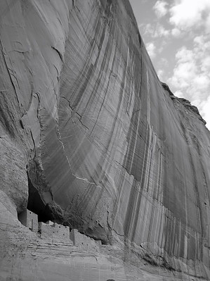
Standing on the edge, the hike down first appears daunting. Fear not as most should negotiate the short descent handily. Once on the canyon floor, the trail takes you on a stroll to the ruins. Anticipation builds with each step. The payoff is a full package of wow. The massive canyon wall cuts in near the base creating a large alcove to protect the ruins.
WARNING! Hiking and outdoor related sports can be dangerous. Be responsible and prepare for the trip. Study the area you are entering and plan accordingly. Dress for the current and unexpected weather changes. Take plenty of water. Never go alone. Make an itinerary with your plan(s), route(s), destination(s) and expected return time. Give your itinerary to trusted family and/or friends.
To hike From Flagstaff go east on I-40 to Highway 191. Go north on 191 to Highway 64. Turn east and drive 2.7 miles to Canyon de Chelly National Monument. Follow South Rim Drive 6.4 miles to the White House Overlook. Park your car. Drop your jaw. Pass out from the energy-zapping your body due to the sheer beauty of your surroundings.
 Route Editor


 Few places offer the beauty found within Canyon de Chelly. It's taken me over a year to calm down and share the experience. After years of reading books and seeing the pictures in Arizona Highways, I knew someday I would go.