 Route Editor

| Guide | ♦ | 275 Triplogs | 0 Topics |
details | drive | permit | forecast | 🔥 route |
stats |
photos | triplogs | topics | location |
| 86 | 275 | 0 |
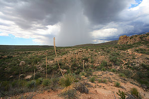
Water? Really? by fricknaley  Catalina State Park is a popular place here in Tucson, the vast majority come to hike to Romero Pools. The beginning part of the Romero Canyon trail provides the first leg of a nice, short loop hike that wanders through the foothills of Catalina State Park and avoids much of the crowds. This is a great short hike for kids in a backpack as well. Catalina State Park is a popular place here in Tucson, the vast majority come to hike to Romero Pools. The beginning part of the Romero Canyon trail provides the first leg of a nice, short loop hike that wanders through the foothills of Catalina State Park and avoids much of the crowds. This is a great short hike for kids in a backpack as well.Begin this short loop from the popular Romero Canyon trailhead and immediately cross over Sutherland Wash, which may have water flowing in it depending on the recent precipitation activity in the mountains. The trail breaks left just after the wash. A sign for the Birding trail breaks away right. Stay left and climb briefly up the slope overlooking Sutherland Wash, then follow the broad sandy trail through the relatively flat land before it truly starts to climb up to the Pools. There are great views over the north side of Pusch Ridge here, particularly the vertical north face of Table Mountain and also Pusch Peak. After 0.6 easy miles on the Romero Canyon trail, you come to the first signed intersection.
Hang a left onto the Sutherland Trail and follow it about 0.8 miles back to the trailhead. This section is basically flat the whole way. It crosses over the wash again twice. Again there may some nice areas with water here. In the spring there is nice, tall grass along the way. Check out the Official Route and Triplogs. Leave No Trace and +Add a Triplog after your hike to support this local community. | |||||||||||||||||||||||||||||||||||||||||||||||||||||||||||||||||||||||||||||||||||||||||||||||||||||||||||||||||||||||||||||||||||||||||||||||||||||||||||||||||||||||||||||||||||||||||||||||||||||||||||||||||


