 Route Editor

| Guide | ♦ | 63 Triplogs | 0 Topics |
details | drive | permit | forecast | map |
stats |
photos | triplogs | topics | location |
| 218 | 63 | 0 |
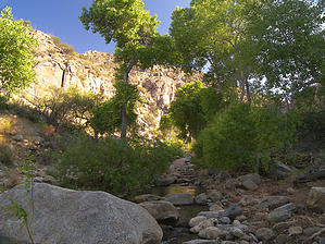
more than meets the eye by PrestonSands   Overview Jacobson Canyon, in Arizona's Pinaleno Mountains, is easily overlooked, as most people speed past it on the Swift Trail highway, bound for the 2-mile high forest at the top of the range. However, riparian flora and fauna thrive in Jacobson Canyon, especially during springtime, when warm weather brings crystal clear snowmelt splashing past water-loving trees and awakens hordes of native frogs. Overview Jacobson Canyon, in Arizona's Pinaleno Mountains, is easily overlooked, as most people speed past it on the Swift Trail highway, bound for the 2-mile high forest at the top of the range. However, riparian flora and fauna thrive in Jacobson Canyon, especially during springtime, when warm weather brings crystal clear snowmelt splashing past water-loving trees and awakens hordes of native frogs.This entirely off-trail and time-consuming hike describes the lower half of the canyon, from its beginning, up to a waterfall near Noon Creek. It is possible to enter or exit Jacobson Canyon almost anywhere, as it parallels the highway for most of its length. Consequently, mileage for this hike can vary. Mileage and time listed is for a ONE-WAY hike up the canyon, which requires setting up a shuttle. Parking your second vehicle at forest road 667, or the Noon Creek Picnic Area will satisfy this requirement. Double the time and distance listed if you choose to hike the canyon round trip. A topo map of the area, as well as Tevas or other sturdy water shoes, are helpful items for this hike.
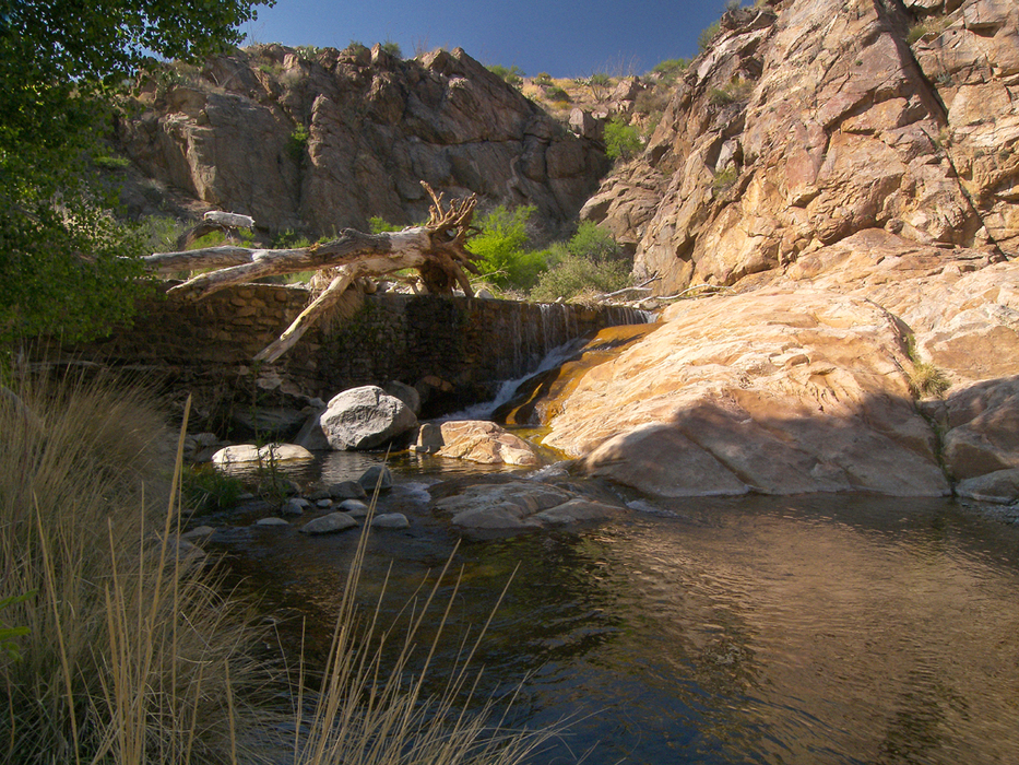
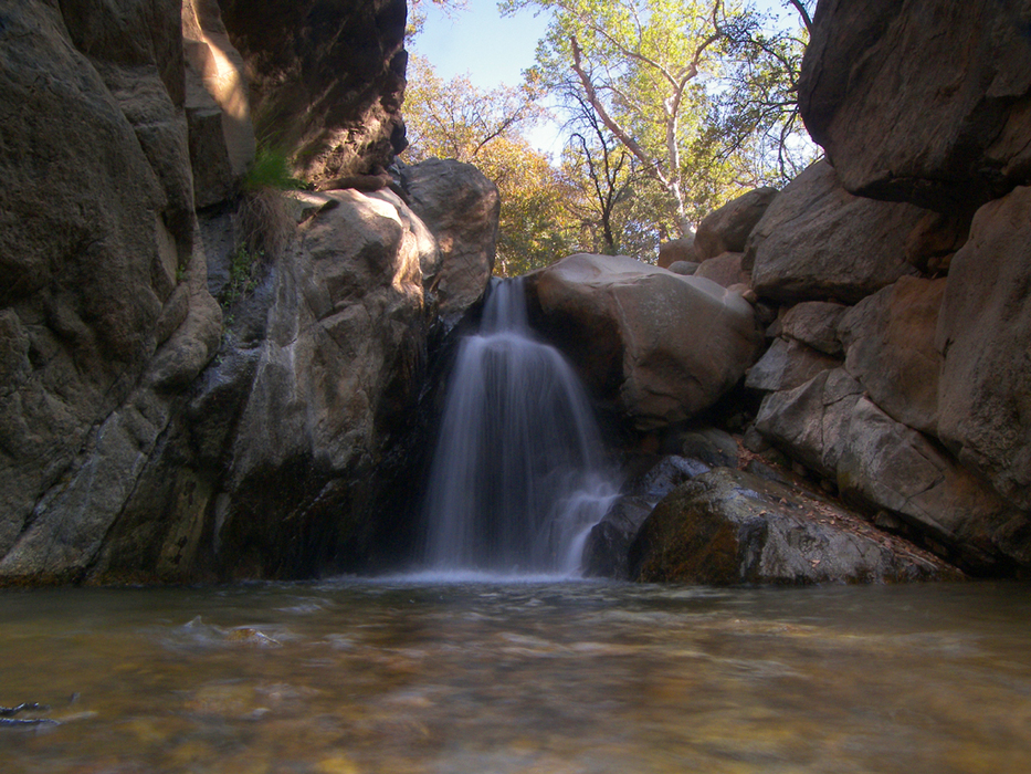
Hike: Jacobson Canyon begins near the first curve on highway 366, right as it enters the Pinaleno Mountains. This makes a good place to begin your hike. There is a dirt pull-off spot on the left (south) side of the highway, at milepost 117.6. Park there, and head several hundred feet further up the highway. At this point, there will be a rocky jeep trail taking off to the left (south). Follow it for a few hundred yards to its end, overlooking Jacobson Canyon. A use-trail drops down the bank to the creek bed, passing through a turnstile-like gate in the fence along the way. Head west up the creek bed, and you will immediately come to an abandoned dam, known as "Johns Dam", which marks the entrance to the first of two narrows. Above the dam, the narrow, sandy bottom of the canyon gives way to an interesting stretch of polished, salt and pepper gneiss, where the creek tumbles in and out of bathtub-sized pools and chutes. The polished rock soon ends, and the canyon widens to reveal a view of the Pinaleno peaks in the distance. The next half mile consists of rock hopping among cottonwoods, willows, and colorful boulders. At around the one-mile point, the canyon bends south, and the walls rise, signaling your entrance into the second narrows. The next quarter mile is a truly beautiful, albeit brief passage, featuring towering cliffs, cottonwoods, cascading water, and a dramatic surge in plant species. The upper narrows come to an end all too soon, where two small side canyons join Jacobson Canyon. The next mile is more boulder hopping through stands of cottonwood and sycamore, as the canyon gains elevation. Just above the 4700-foot contour, an obvious trail crosses the creek bed (32.66990 N, 109.78502 W). Take notice of this trail, as it provides a convenient escape route back to the highway if you have chosen not to return via the canyon. Shortly above the trail crossing, Noon Creek joins Jacobson Creek on the right, and the south canyon wall closes in, narrowing the creek bottom. Poison ivy along the nearly vertical banks funnels you into the creek itself. One-tenth of a mile upstream of the confluence with Noon Creek, the hike reaches a dead end among low cliffs, at the upstream end of which is a 15-foot waterfall and a small pool. You could continue up canyon beyond the waterfall, but bypassing it by climbing the slick, vertical rocks near the falls would be tricky. Unless you have chosen to return via the canyon, retrace your steps to the trail crossing, near Noon Creek. By following this trail for a quarter mile or so up the north/west bank, it will take you back to the Swift Trail highway. One-tenth of a mile up the trail, it splits. The right fork switchbacks up the slope and comes to an end 50 feet below the highway. The left fork (more traveled) leads to a forest service administrative site, where you can follow its access road (forest road 667) back to the highway. Gate Policy: If a gate is closed upon arrival, leave it closed after you go through. If it is open, leave it open. Leaving a closed gate open may put cattle in danger. Closing an open gate may cut them off from water. Please be respectful, leave gates as found. The exception is signage on the gate directing you otherwise. Check out the Triplogs. Leave No Trace and +Add a Triplog after your hike to support this local community. One-Way Notice This hike is listed as One-Way. When hiking several trails on a single "hike", log it with a generic name that describes the hike. Then link the trails traveled, check out the example. | ||||||||||||||||||||||||||||||||||||||||||||||||||||||||||||||||||||||||||||||||||||||||||||||


