Route Editor

| Guide | ♦ | 35 Triplogs | 0 Topics |
details | drive | permit | forecast | 🔥 route |
stats |
photos | triplogs | topics | location |
| 223 | 35 | 0 |
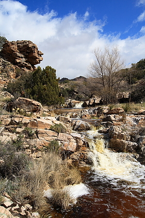
This ridge is la milagrosa (miraculous) by fricknaley  Overview: This is another beautiful trail out in the area around Agua Caliente Hill, at the far east end of the Catalinas. Like the other trails in this area, the forest service makes no mention of it - it is unsigned but totally obvious and well-hiked. This particular trail hikes the La Milagrosa ridgeline out to the junction with the Bellota section of the Arizona Trail. Overview: This is another beautiful trail out in the area around Agua Caliente Hill, at the far east end of the Catalinas. Like the other trails in this area, the forest service makes no mention of it - it is unsigned but totally obvious and well-hiked. This particular trail hikes the La Milagrosa ridgeline out to the junction with the Bellota section of the Arizona Trail.Hike: This hike begins at the intersection of N. Avenida de Suzenu and Horsehead Roads. Walk around the gate onto Horsehead Road and blast out the initial boring segment of this hike, a roughly 0.6-mile or so walk down the road to the mouth of La Milagrosa Canyon. Near the end of the road, you will walk past the intersection of Wentworth road, and then the trail drops across a little wash (which will flow after rain) and crosses over a small gate that will likely be trampled over. After climbing up the other side the trail now obviously is heading towards the converging La Milagrosa and Agua Caliente canyons. The first left is a spur to an old, abandoned shack which you should ignore. The real trail contours down and to the left beyond the remnants of the house. A quick descent takes you to the intersection of interest. Take a left here onto the La Milagrosa route. A right leads towards Agua Caliente canyon. The left you took will almost immediately start you climbing up the western flank of La Milagrosa Canyon and the views are almost immediately sweet. At about 1.3 miles from the start you come to a hikers gate on the climb up the canyon flank. Pass through here and continue your ascent up the western ridge of the canyon. Before too long you reach the highpoint on this side of the canyon (with spectacular views up the canyon to prove it) and begin a short earnest descent back down to the canyon bottom, at the location of a great rock shelf sitting across the canyon bottom. At times of water flow, any number of little falls will spill off this excellent slab of rock.
Continue hiking along this excellent route further out into the hills between the Catalinas and the Agua Caliente Hill formation, climbing up or skirting several ridgeline points along the way. The views ahead and to the right are always great, and to the left, the views down into La Milagrosa Canyon are generally splendid. Ultimately the trail finally curves north and begins a descent toward the top of the canyon, and descends to its floor. Again, when water is running this is a wonderland of cascades and falls. A broad creek crossing after this spot will bring you to an unmarked, unsigned intersection with a wide, sandy trail - the Bellota Trail, a section of the Arizona Trail. This is the end of the La Milagrosa Ridge trail, never signed or marked in any way yet truly excellent nonetheless. It is about 5.25 miles from your car. Return the way you came. Gate Policy: If a gate is closed upon arrival, leave it closed after you go through. If it is open, leave it open. Leaving a closed gate open may put cattle in danger. Closing an open gate may cut them off from water. Please be respectful, leave gates as found. The exception is signage on the gate directing you otherwise. Check out the Official Route and Triplogs. Leave No Trace and +Add a Triplog after your hike to support this local community. | |||||||||||||||||||||||||||||||||||||||||||||||||||||||||||||||||||||||||||||||||||||||||||||||||||||||||||||||||||||||||||||||||||||||||||||||||||||||||||||||||||||||||||||||||||||||||||||||||||||||||