 Route Editor

| Guide | ♦ | 221 Triplogs | 0 Topics |
details | drive | no permit | forecast | route |
stats |
photos | triplogs | topics | location |
| 289 | 221 | 0 |
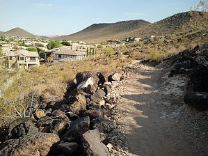
Milquetoast Special by Barrett  History HistoryThe Thunderbird Conservation Park located along Pinnacle Peak west of 55th Avenue is named after a WWII Fighter plane training facility that used to be located 4 miles south of the park. Its trails wander up and around the Hedgepeth Hills, named for the Hedgepeth Ranch that used to be at the site. Overview Formerly known as H-1. Travels from the horse staging area just inside the 67th Ave park entrance over to its terminus at the intersection of 55th Ave and Potter. The new name is apt, as the trail is in the shape of a whip, forming a hairpin along with several lesser bends. It also connects with several other trails and is rarely hiked from end to end as it is impossible to loop. I'll refer to it as H1, as that's what the trail signs still read.
Starting at the horse staging area, the trail heads south across a flat section with sparse vegetation and 2 connections leading left Sunrise Trail, followed by 2 on the right (unnamed, they lead to 67th Ave). The trail then gains some elevation and heads east along the southern slope until it reaches the H4 intersection on your left at 0.5 miles. The next 0.6 miles will drop you down into a small wash and up some switchbacks, topping out for some nice views of the park and Phoenix in the distance before dropping you down into the center of Thunderbird Park proper. There you will find restrooms, water, a large amphitheater, ramadas, stone barbecues, even a rotisserie big enough for a pig roast (call 602-344-6940 for ramada reservations, beer permits, and the lock code for the rotisserie). It's about 0.2 miles to cross the park and pick up H1 as it climbs up to the H3 Cholla Trail junction on your left, where you continue east towards the pedestrian bridge that is a shortcut across the Coachwhip hairpin. If you continue straight, you will cross the intersection of 55th Ave/Pinnacle Peak, reaching the eastern trailhead after 0.7 miles (no facilities). Following H1 west, now on the south side of Pinnacle Peak, you'll notice the vegetation difference between the north and south-facing slopes. The sun-drenched slope north of Pinnacle Peak has Brittlebush, Creosote, Palo Verde, along with Saguaro, Barrel, Cholla, and Buckhorn Cactus. The south side is primarily Brittlebush, with just a few Palo Verdes in contrast. 0.7 miles from the road crossing you will reach the pedestrian bridge again, and a few ramadas as well, from there the trail turns south and descends some switchbacks to the sedimentation basin where you will find three sets of viewing blinds to check out the 50+ species of birds that frequent the area. Bring binoculars or a high-power lens though - the blinds are set far back from the pond so as not to disturb the wildlife. 1.5 miles from the bridge you will cross another paved road at the entrance to Arrowhead Manor Estates, a gated community of exactly 3 houses (?). From there you can enjoy the views of people's backyards and the sounds of barking dogs for another 0.5 miles until you reach the trail's end at the intersection of 55th Ave and Potter. The least challenging and scenic of the Thunderbird Park trails, H1 is nonetheless convenient for those who live near its trailheads or use it in connection with other trails to form loops. The geology is mostly volcanic tuft, with a few outcroppings darkened with desert varnish. Birdwatchers will enjoy the viewing blinds, and the trail is smooth enough for trail-running over most of its course. In over 400 trips to the park, I have seen Coyotes, Rattlesnakes, Cottontails, and numerous lizards, but in general, it is an urban park with scarce wildlife beyond the sedimentation basin. Gate Policy: If a gate is closed upon arrival, leave it closed after you go through. If it is open, leave it open. Leaving a closed gate open may put cattle in danger. Closing an open gate may cut them off from water. Please be respectful, leave gates as found. The exception is signage on the gate directing you otherwise.
Check out the Official Route and Triplogs. Leave No Trace and +Add a Triplog after your hike to support this local community. One-Way Notice This hike is listed as One-Way. When hiking several trails on a single "hike", log it with a generic name that describes the hike. Then link the trails traveled, check out the example. | |||||||||||||||||||||||||||||||||||||||||||||||||||||||||||||||||||||||||||||||||||||||||||||||||||||||||||||||||||||||||||||||||||||||||||||||||||||||||||||||||||||||||||||||||||||||||


