 Route Editor

| Guide | ♦ | 196 Triplogs | 0 Topics |
details | drive | no permit | forecast | route |
stats |
photos | triplogs | topics | location |
| 20 | 196 | 0 |
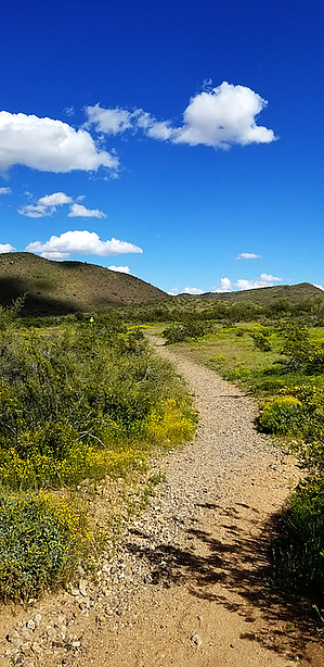
Nobody's Favorite by joebartels  Overview OverviewOriginates at 67th Avenue and Patrick Lane parking lot and concludes at parking lot "B" off 61st Ave. Originally named H-5. A Desert Iguana is a lizard not often posted in photos on HAZ. Hike From the 67th Ave lot, Desert Iguana Trail begins with a gentle 32-foot incline. Which is the toughest ascent following West to East. Ludden Mountain NNE, just north of Happy Valley Rd intrigues. The lower foreground ridge behind the neighborhood is the NE corner of this park. The visible trail along that hill is the Cholla Trail.
I would rate the tread as excellent 5-10 miles per hour on a bike. The park limit is 15 mph on bikes, which seems likely for the midsection. The east is a bit gravelly, not much. This trail is most enjoyable in cool spring weather or the rising/fading sunlight. Trails are open from sunrise to sunset. The east end crosses a shallow ravine near the 61st Ave "B" lot. Which borders a neighborhood. This ravine has substantial vegetation unlike the western 95% of Desert Iguana. Weapons Slingshots, bow-n-arrows, and knives with a blade over a 3½-inch are not permitted on the trails. A hiking stick can serve to fend off any wildlife. The only wildlife I saw was one Quail. It did not pose a threat.
Check out the Official Route and Triplogs. Leave No Trace and +Add a Triplog after your hike to support this local community. One-Way Notice This hike is listed as One-Way. When hiking several trails on a single "hike", log it with a generic name that describes the hike. Then link the trails traveled, check out the example. | ||||||||||||||||||||||||||||||||||||||||||||||||||||||||||||||||||||||||||||||||||||||||||||||||||||||||||||||||||||||||||||||||||||||||||||||||||||||||||||||||


