 Route Editor

| Guide | ♦ | 34 Triplogs | 0 Topics |
details | drive | permit | forecast | route |
stats |
photos | triplogs | topics | location |
| 129 | 34 | 0 |
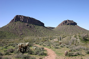
The best of San Tan Mountain Park by ferazamboni  Overview OverviewThe Malpais trail is a 4.2-mile loop that accesses the beautiful and remote southwestern part of the San Tan Mountain Regional Park. If you have the time, this is the hike you'll want to do while visiting the park. Due to its more remote location, length, and significant hiking in sandy washes, this trail receives less usage than other trails in the park. Reaching the trail requires first hiking into the park from one of the three main trailheads, which adds length to the total trip mileage. Much of the trail follows a sandy wash so it's a good idea to wear hiking boots that will give support and keep sand out. Access There are three ways to access the trail. If you want to minimize your mileage, the Rock Peak Wash trailhead is your best bet. Starting from this trailhead only requires a 1.4-mile hike (one-way) on Rock Peak Wash Trail to reach the start of the Malpais Trail. Starting from the visitor center trailhead requires a 2 mile (one-way) hike to reach the Malpais trail, and from the Goldmine Trailhead would require 4.1 miles (one-way). Consult the park map to decide which option suits your needs. This trail description is based from the visitor center for an 8.8-mile loop hike.
To access the visitors center trailheads you need to either pay per vehicle, or you can opt to bike/walk in from outside the park entrance and pay a smaller fee. From this main trailhead head south on the San Tan Trail. This is a wide and flat trail that connects with many other trails in the park. Along this section be on the lookout for mountain bikers and horses. Bikers tend to ride fast on the flat and wide sections of this trail. The trail etiquette is for bikers to yield to hikers, and hikers to yield to horses. After 0.6 miles, you reach the junction with the Stargazer Trail. Continuing south on the San Tan Trail another 0.3 miles, you reach the junction with the Hedgehog Trail. Head southwest on the Hedgehog Trail, which climbs slightly between two hills. From this trail, you'll have nice views of the Superstition Mountains, Four Peaks, and Pinal Mountains to the East. Continue on the Hedgehog Trail for 0.9 miles until you reach the junction with the western end of the San Tan Trail. From the junction with the San Tan Trail, head west on the San Tan Trail for 0.2 miles until the junction with the Malpais Trail. Take a break here before embarking on the 4.2-mile trek along the Malpais trail. Heading southwest on the Malpais Trail you will go up in elevation as you climb to the top of a hill. At the top of the hill is an interesting group of rocks guarded by a devilish saguaro cactus. From here you will begin a long trek westward along the fence that divides the park and the Gila River Indian Reservation. This is a good time to watch for birds flying from one saguaro to another and inspect some of the desert vegetation more closely. After about 2 miles the trail turns (finally!) south and drops into a sandy wash as it approaches the base of the large mountain range that encompasses the southern end of the park. It is here that the park really shines. The beauty of the mountains combined with the vegetation and wildlife make for the perfect Sonoran desert scene. Look for hawks making a ruckus and soaring playfully along the mountainside. The only thing missing in this part of the park are some benches to sit down and relax at (oh, and a summit trail!). The trail now turns back east, continuing for 2 miles in the same sandy wash. As you head east Rock Peak will soon become visible. Once you reach the junction with the San Tan trail, take a moment to look back at the mountains you just hiked along. It's interesting how different they look from this perspective as compared to when you originally approached them on the Malpais trail. From the junction head north on the San Tan Trail for 0.7 miles until you reach the Hedgehog Trail. Return to the visitor the same way you came in using the Hedgehog and San Tan trails. The park visitors center has a nice memorial of the Arizona residents who lost their lives in the Iraq and Afghanistan wars. There is also a Desert Tortoise Habitat that provides an up-close look at how these animals live and what they eat. The visitor center shop has a few items for sales as well.
Check out the Official Route and Triplogs. Leave No Trace and +Add a Triplog after your hike to support this local community. One-Way Notice This hike is listed as One-Way. When hiking several trails on a single "hike", log it with a generic name that describes the hike. Then link the trails traveled, check out the example. | ||||||||||||||||||||||||||||||||||||||||||||||||||||||||||||||||||||||||||||||||||||||||||||||||||||||||||||||||||||||||||||||||||||||||||||||||||||||||||||||||||||||||||||||||||||


