username
X
password
register
for free!
help
  

Desert View Trail, AZ

Guide 13 Triplogs  0 Topics
  2 of 5  
Fav
Wish
0
details
drive
permit
forecast
route  
stats
photos
triplogs
topics
location
144 13 0
Statistics
tap row or icons for details
Difficulty 0.5 of 5
Route Finding 1 of 5
Distance Loop 1.1 miles
Trailhead Elevation 1,738 feet
Elevation Gain 164 feet
Accumulated Gain 180 feet
Avg Time Round Trip <1 hour
Kokopelli Seeds 2
 Backpack No
 Dogs not allowed
feature photo
Photos Viewed All MineFollowing
Inaugural Calculation on Button Tap!
20  2025-02-08
Red Tanks Tinaja and Baker Mine AZ
trekkin_gecko
13  2025-02-08
Red Tanks Tinaja and Baker Mine AZ
johnlp
6  2017-02-21 rwstorm
9  2016-04-02 trekkin_gecko
8  2016-04-02 BiFrost
5  2016-04-02 rwstorm
15  2016-04-02 tibber
54  2013-12-28
Organ Pipe (ORPI) Dec2013
Randal_Schulhaus
Page 1,  2
Author
author avatar Guides 19
Routes 40
Photos 5,624
Trips 341 map ( 3,929 miles )
Age 52 Female Gender
Location Tucson, AZ
Associated Areas
list map done
Southwest Region
Historical Weather
Trailhead Forecast
Radar Map
Expand Map
Preferred Dec, Jan, Feb, Mar → 7 AM
Sun  6:08am - 6:52pm
Official Route & 2 Rts
 
1 Alternative


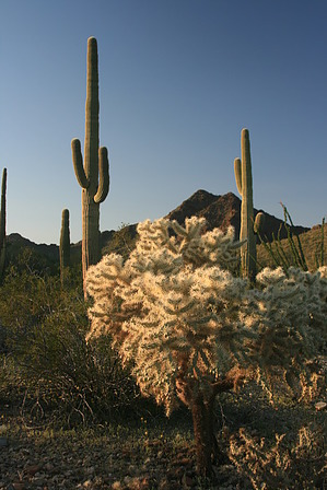
A safe place to see some cacti.
by writelots

Overview
From the NPS: Leaving from the Group Campground, this trail leads you on a trip through native vegetation and tells a story of how people use the desert to make a living.


Hike
This short loop leads through the low foothills near the visitor center - the most heavily used part of the park. However, as the trail winds through stands of Organ Pipe, Saguaro, Ocotillo, Barrels, Hedgehog, Prickly Pear, Cholla, and Mammillaria, even the most jaded desert visitor can find themselves enchanted by the sheer diversity of life found on these slopes. The interpretive signs are subtle and have some fun facts, mostly focused on the uses of the plants to the native peoples. The grade stays even and steady, making for nearly mindless walking as you explore the finer details of the desert.
remove free decal offer
Just when you think it's all going to be down in the valley and washes, the trail begins a gradual climb up to a ridgeline which offers amazing views to the south and west. Sweeping vistas of Sonoyta Valley and the pink granite of the Cubabi Mountains in nearby Mexico open up, and a couple of benches are placed for capturing a desert sunset. When we visited, the views were crowded with RVers, equipped with cameras, tripods, and glasses of red wine. Too bad the sunset was lackluster...

The trail meanders back down to the group campground, a little steeper in this direction, with some steps installed to keep everything smooth and easy. It's a perfect hike for visitors, to those uninitiated with the Sonoran Desert, and for seasoned hikers looking for a quick stroll to round out the sunset.

2010-03-23 writelots


    Check out the Official Route and Triplogs.
    Leave No Trace and +Add a Triplog after your hike to support this local community.
    WARNING! Hiking and outdoor related sports can be dangerous. Be responsible and prepare for the trip. Study the area you are entering and plan accordingly. Dress for the current and unexpected weather changes. Take plenty of water. Never go alone. Make an itinerary with your plan(s), route(s), destination(s) and expected return time. Give your itinerary to trusted family and/or friends.

     Permit $$
    NPS

    Organ Pipe Cactus National Monument
    $15.00–$25.00 Fees & Passes

    Entry fees to the Organ Pipe Cactus National Monument are as follows:
    Private vehicles (including all occupants): $25
    Motorcycles (including passengers): $20
    Bicycles and Walk-ins: $15 per person

    The fees above are good for 7 consecutive days.

    Interagency passes are accepted in lieu of the above fees.

    Camping fees are as follows:
    Twin Peaks Campground: $20 per night (An established campground with facilities, tent, and RV camping.)
    Alamo Canyon Campground: $16 per night (A primitive campground for tent camping only.)
    Backcountry camping: $5 per permit (valid for 7 days)


     Directions
    or
     Road
    Paved - Car Okay

    To hike
    From Phoenix: Take I-10 west to AZ Highway 85. Follow south through Buckeye, Gila Bend, Ajo, and Why. The Monument is 4 miles from Why. The Kris Eggle Visitor Center is 22 miles (35.4 km) south of Why. The trailhead is located in the parking area for the Group Campsite.

    From the Tucson: Take Ajo Road, which turns into Arizona Highway 86 through Sells and Why, then turn south on Arizona Highway 85.
    page created by writelots on Mar 23 2010 5:42 pm
     90+° 8am - 6pm kills
    helpcorrectionissue

    end of page marker